
雪崩情報
更新日時: 2022/01/15 07:00
ニセコ・羊蹄・余市・尻別
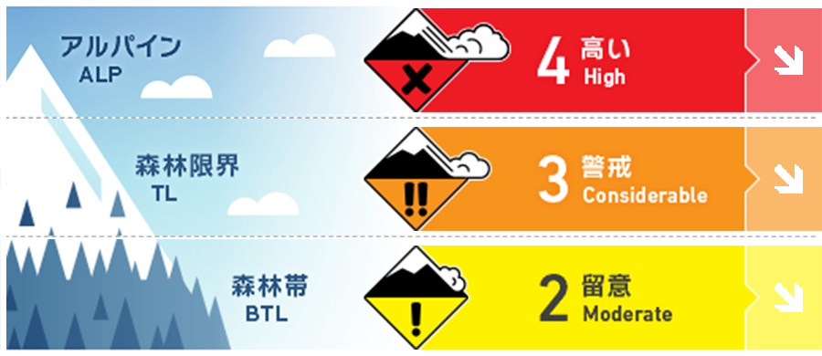
アルパイン Fair 強風が最近の雪を移動させ、風下側にスラブを形成させています。High winds speed will have transported the latest new snow onto lees slopes producing slabs
森林限界 Good 森林限界は、ストームスラブが特定の場所に偏在しており、地形選択が難しい状況です。真新しい雪崩の発生跡などを探してください。The treeline has the potential for difficult terrain choice decisions with wind slabs likely to be found on the lee and storm slabs in specific areas. Look for signs of recent activity.
森林帯 Good 一般的な安全なルート設定をしてください。標高の低いところでは、斜面上方からでは視認できないグライドクラックに注意が必要です。Normal safe travel techniques are required. Be wary of glide cracks at lower elevations that may not be seen from above.
信頼度:○ good □ Fair △ Low
行動と地形の助言
天候が回復したら、急斜面、特に東斜面に真新しい雪崩の跡がないか、探してみてください。荒天が何日も続いた跡は、目的のルートを慎重に考え、雪崩の危険度が高い斜面に入る前に、小さい安全性の高い斜面でコンディションを確かめてください。バックカントリーでの行動に適した日は数日続きそうですので、今日は積雪の状態を確認するのに時間を使ってください。As the storm lifts look for signs of recent activity on steep terrain especially on Easterly slopes. After multiple days of stormy conditions take the time to fully assess your desired route and choose less consequential terrain to build confidence on conditions before moving onto more exposed slopes. We should have a few good days coming up to get further into the backcountry so take the time to test the snowpack.
留意すべき雪崩
ストームスラブ Storm slab


風の影響の弱いところでは、ストームスラブが存在しています。風や気温の変化によって、荒天の雪が不安定となり、大きな荷重で誘発される可能性があります。In protected areas not affected by the winds, storm slabs may be found. Instabilities within the latest storm snow due to changes in the wind direction and speeds along with temperature changes during the storm could be reactive to heavier loads.
ウインドスラブ Wind slab


北西の強風が続き、アルパインや森林限界では、風下側にウインドスラブが形成しています。積雪を支えないような地形や、急な開放斜面では、滑走者1人の刺激で雪崩を起こす可能性があります。凸状地形や、その他の誘発しやすい箇所に注意し、稜線直下の東側に存在し、一見滑らかにみえる局所的なウインドスラブなどに警戒してください。Multiple days of strong to gale winds from the North West will have created slabs on lee slopes in the alpine and tree line. In open unsupported steep terrain, these slabs could be triggered by single-person loads. Be wary of convex rolls and other stress points and look for visual clues of where the slab are loacted in the East such as smooth wind-pressed pockets below ridgelines.
概要
雪崩
1月13日、スキーパトロールによる爆発物の雪崩管理でサイズ2の雪崩が東斜面ででています。破断面は1m 程度です。点発生乾雪表層雪崩が、走路内にあるスラブを刺激し、サイズ2の雪崩へと拡大しました。縦長に流れていますが、十分に人を埋める量の雪が動いています。A local ski patrol published avalanche activity up to size 2 on a SE aspect during active control operations using explosives on the 13th Jan. Crown walls were recorded up to 1 meter deep. A loose dry avalanche in steep terrain also on the Easterly half triggered a buried slab at a lower elevation in its path. This slab produced a long narrow size 2(enough debris to bury a person).
積雪
前回の雪崩情報から、フィールドの雪は、北西の風の影響を強く受けた40 cmの新雪が加わっています。観察は限られていますが、森林帯では新雪と旧雪の結合は良くなってきているようです。この状態は数日、続くと思います。一方で、荒天の雪の中にある不安定要素も確認されており、それがもう少し安定するまで時間が必要です。Since our last forecast, we have continued to be heavily influenced by the NW winds combined with 40 cm on new snow accumulation. Observations have been limited but in the treeline, it appears the latest new snow has begun to bond well with the previous snow surface. We expect this to continue in the coming days however mid-storm instabilities have been observed in the latest snow and slabs will have formed that need further investigation and time to settle.
天候
この荒天は土曜には終わり、北西の風も弱まり、降雪も減る予報が出ています。日中は雲が切れ、気温が上がり、日曜日には南風が入ってくるとのことです。The latest storm period will break on Saturday as the constant NW winds begin to ease and new snow totals lessen over the weekend. We expect broken clouds during the days and warmer temperatures as the winds move back round to the South on Sunday.


