
雪崩情報
更新日時: 2022/01/29 07:00
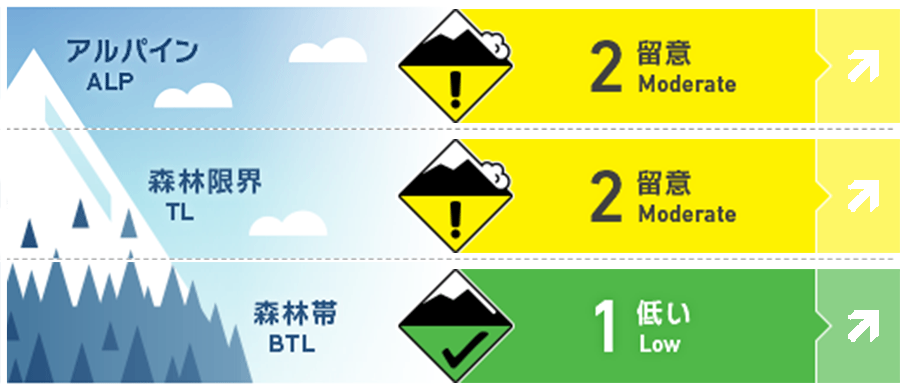
ニセコ・羊蹄・余市・尻別
アルパイン Good とても急な斜面や南に面した場所で、点発生雪崩の痕跡を探してください。Look for tell-tale signs of point release activity in steep terrain and on Southerly aspects.
森林限界 Good 滑るときも、登るときも、安全な行動様式を忘れないでください。少しの雪が動く雪崩でも、足元をすくうことを忘れないように。Remember to use safe travel techniques on the way down as much as the way up and be mindful of the consequence if you lose your feet even in a low-volume avalanche.
森林帯 Good グライドクラックが降雪でやや隠れています。標高の低い地域で活動する方は、十分気をつけてください。Be wary of glide cracks that may now be slightly buried at lower elevations.
信頼度:○ good □ Fair △ Low
行動と地形の助言
長い降雪のない期間を終えた時に出現する「サミットフィーバー」に捉まらないように。ノートラックのラインは、今後、予報されている降雪の状況を考えれば、毎日、楽しめるはずだからです。滑走する前に、自分にとって良いラインを考えるかと思いますが、その思考プロセスを利用して、現在の計画が十分に信頼度のあるものなのか、なにか変更を加える必要性があるのかを考えてみてください。稜線の雪庇は、とても不安定な可能性が高く、標高の低い場所ではグライドクラックが降雪で隠れており、重大な結果をもたらす可能性があることも忘れずに。After a long period of dry conditions don't let summit fever grab you. Fresh lines will be available in the coming days as we receive daily top-ups of new snow. Have a clear idea in your head before getting on snow for what you think you are going to find and use this process to build confidence in your plan or know when to turn around. Cornice may be brittle up high at ridgeline and low down glide cracks are ever-present and could have high consequences.
留意すべき雪崩
点発生乾雪雪崩 Dry Loose snow


降雪量が増えるにつれて点発生雪崩も、人の刺激で反応しやすくなります。数日の好天による日射によって形成した硬い雪面と、新たな降雪の結合ぐあいを確認してください。As new snow accumulation continues to grow loose snow activity may become reactive to single person loads in steep terrain. After numerous days of broken clouds and sunshine earlier in the week test the bond between the latest new snow falling on a temperature crust formed during that period.
概要
雪崩
過去数日、点発生雪崩などの活動報告があります。Now new avalanche activity had been reported over the last few days.
積雪
現在、森林限界付近で最大50 cmの新雪があり、今後、数日でさらに降雪量が増えると予報されています。その下層にある旧雪層は、全体的に安定した状態にありますので、この新旧の境界面がどのように結合していくのかが焦点です。また、先週の好天で形成した融解凍結クラストとの結合具合をみていくことが、状況判断の良い材料となるはずです。Currently, we have accumulated up to 50cm of new snow at treeline with more forecast during the coming days. Overall the snowpack remains stable with our focus is now on how the new and old snow interface will bond. The crust formed due to sunshine over the last week should be a key target for information gathering.
天候
低気圧が北海道を包み込み、地域全体に降雪が始まりました。週末に向けて、さらなる降雪が予報されています。また風は、西寄りですが、弱~中程度にとどまる見込みです。As a low-pressure system wrapped around North of Hokkaido snowfall began to fall across the region at the end of this week. Further snowfall is forecast throughout the weekend. Winds will remain low to moderate from the West in the coming days.


