
雪崩情報
更新日時: 2022/02/01 07:00
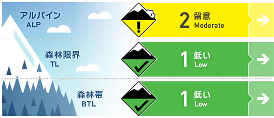
ニセコ・羊蹄・余市・尻別
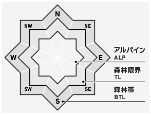
アルパイン Good アルパインの風下斜面の局所にスラブが形成しています。南向きの斜面では特に注意が必要です。Pockets of slab have formed in the alpine on lees slopes. Extra caution should be taken on Southerly aspects.
森林限界 Good 急な斜面では小さい点発生雪崩が発生しえます。Steep terrain may produce low volume loose dry activity.
森林帯 Good 安全な行動様式を使い、拡大しているグライドラックの危険に対処してください。Safe travel techniques should be used and be mindful of the ever-growing glide cracks.
信頼度:○ good □ Fair △ Low
行動と地形の助言
引き続き、新雪と旧雪の境界面の状態の把握に時間を掛けてください。風の影響の弱い北側では良い滑走感を楽しめるでしょうが、南側ではクラストが、それを邪魔するかもしれません。標高の低い場所では拡大するグライドクラックに警戒してください。Continue to take the time to test the new old snow interface. Protected Northerly aspects will ski and ride well whilst you may feel the crust in the South. Lower down glide cracks continue to grow.
留意すべき雪崩


急斜面での点発生雪崩に対処するため、一般的な安全行動を使ってください。雪崩の発生の可能性は限られた地形のみであり、その量も少ないと評価されています。Regular safe travel techniques are required to manage loose dry activity in steep terrain. Any activity is expected to be isolated and low volume.
ウインドスラブ Wind slab


スラブの形成に適した速度の西~北西の風によって、標高の高い風下斜面の局所にウインドスラブが形成しています。先週の好天時に形成した融解凍結クラストが、このウインドスラブによいすべり面となります。With plenty of available snow to transport moderate West to North West winds have created low volume pockets of slab on lee slopes at higher elevations. A temperature crust formed during the broken sunshine last week is now providing a bed surface for these slabs to slide on across the Southerly solar aspects.
概要
雪崩
昨日(1月31日)、尻別岳の南東斜面で人的な誘発による雪崩がありました。滑走者が凸状地形に誘発し、破断面の深さは30~50 cmです。滑走者はスラブからすぐにエスケープできましたので、怪我などはありません。当事者の観察によると、このスラブは融解凍結クラストとの境界で発生したようです。観察結果を送っていただきましてありがとうございます。情報は、直接、Forecaster Teamに送ることも可能です(forecasters@nadare.jp)。 A human-triggered avalanche was reported on the 31st on a South Easterly aspect on Mt Shirebetsu dake. This avalanche was triggered as the skier went over a convex roll and the crown wall was approximately 30 - 50cm deep. The skier that triggered the slide could immediately ski off the slab and was unharmed. The group's observations were that 30 - 60cm of cold denser snow was overlying a crust on this aspect. Thank you for sending the observations, the forecast team can be contacted directly with any observations at forecasters@nadare.jp.
積雪
私たちは南側に堆積した新雪と旧雪の結合状態に着目しています。適度な風が、先週の日射によって形成した融解凍結クラストの上に、厚み60 cm程度の軟らかいスラブを作りました。標高の低い場所では、雪は焼結し、積雪は安定していることが見て取れます。As expected our concern with the pack is focused on the bond of the latest new snow across the Southerly aspects. Moderate winds have created pockets of soft slab at higher elevations up to 60cm that overlay a crust formed as the sun shone last week. Lower, the snowpack appears strong and well rounded.
天候
この週明けは、一連の降雪が途切れ、今後数日間は、くもりとなる予報です。風は弱~中程度の西風となるようです。After daily top-ups of fresh snow, it is likely that we will see a brief break in snowfall for the early part of the week with broken clouds expected over the next few days. Winds will remain low to Moderate from the West.