
雪崩情報
更新日時: 2021/01/16 06:00
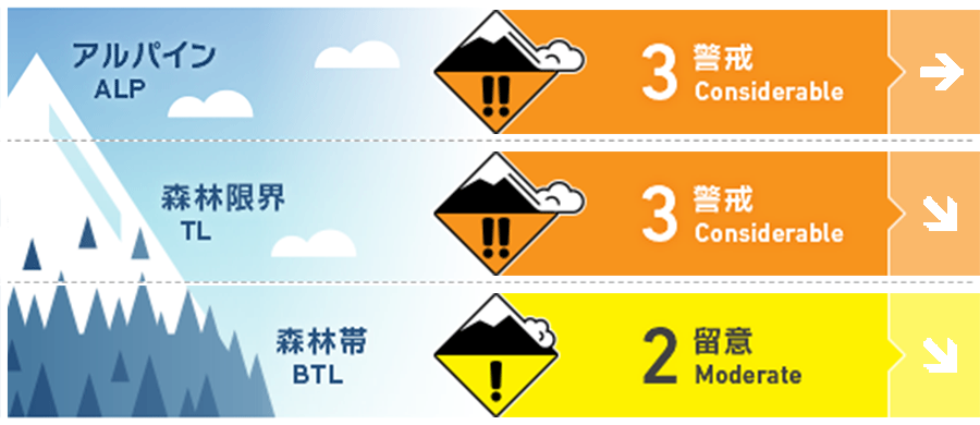
ニセコ・羊蹄・余市・尻別
アルパイン Fair Winds slab development has occurred caused by Strong to Gale Southerly winds from the mid-week onwards. 今週半ばからの強い風でスラブが発達しています。
森林限界 Good Warm temperatures from the Southerly winds have heated the upper sow pack resulting in the possibility of wet loose avalanches in steep unsupported terrain. Be wary of crossing steep slopes at lower elevations above any terrain traps. 南寄りの風の影響で気温が上昇し、積雪表層が温められました。地形が支えない急斜面で濡れた点発生雪崩の可能性があります。標高が低い場所では、急斜面の下にある「地形の罠」に注意が必要です。
森林帯 Good Possibility if loose wet activity due to warm temperatures on Friday night to Saturday lunchtime. 昨晩から本日昼までの高い気温の影響による。
信頼度:○ good □ Fair △ Low
行動と地形の助言
With plenty of wind over the previous week, frozen snow and ice dislodged from trees can be found lightly covered by fresh snow in the forests. Hitting these chunks at speed can cause plenty of damage. Cornice has also been observed growing across ridgelines. The recent heating trend may result in them being harder to trigger requiring greater loads but if they do they are likely to break apart in large chunks. Be wary of what you are standing on. この一週間は風が強かったこともあり、樹林帯の中でも雪が移動し、以前の融解凍結あるいは削剥した凸凹の雪面が観察できました。スピードを出してまま、これらに引っかかると怪我の原因となります。また、雪庇が大きく成長しています。昇温の影響もあり、大きな雪塊の状態で崩落しやすくなっていると考えてください。その下に入らないように。
留意すべき雪崩
点発生湿雪雪崩 Wet Loose snow


Any loose wet activity will need steep slopes to trigger. Watch for any terrain traps below and be wary of cutting steep-sided river beds especially if there is open water below. 濡れた雪が動くには、急な斜面が必要です。地形の罠に注意を払い、急峻な側面を持つ川底を横切る時は、その下に水が流れ入る可能性を忘れずに。
ウインドスラブ Wind slab


Look for signs of smooth pressed snow in Alpine and be wary of convex roles on Northerly aspects. アルパインでは雪の沈降の状態を確認してください。北側の斜面では凸状部に注意してください。
概要
雪崩
Size 1 wind slabs have been observed over the previous week across Nothery aspects. 先週から北側の斜面では、size 1のウインドスラブの雪崩が観察されています。
積雪
After multiple days of Strong to Gale, winds temperatures have risen on Friday night resulting in the possibility of loose wet activity at lower elevations. If temperatures drop over the weekend we expect this instability to stabilise but may then produce a frim bed surface for any new snow falling on Saturday night into Sunday. At higher elevations we expect pockets of wind slab to remain in the Alpine. These pockets are likely to be isolated and smaller in size but could be reactivated to single person loads in steep terrain if they have not been affected by the warmer temps 強風が続いた後、暖かい風が金曜の夜に入りました。これにより濡れた雪の可能性が高まっています。この週末に気温を下がれば、この不安定性は解消されると考えられますが、引き続き、降雪が予報されています。標高の高いところでは、地形的な局所にスラブが形成されていることを考えてください。このスラブが昇温の影響を受けていない、孤立した急峻な地形にある場合、人の刺激で反応しえます。
天候
A low-pressure system is due to cross Hokkaido on Saturday producing a wind change back to the North West and a drop in both wind speed and temperature. Snow is expected to begin falling when this occurs and continue through Sunday. 北海道上空を本日、低気圧が通過、その後、北西の風に変わり、気温が低下する予報が出ています。降雪は日曜まで続くとのことです。


