
Avalanche Bulletin
更新日時: 2021/03/13 06:17
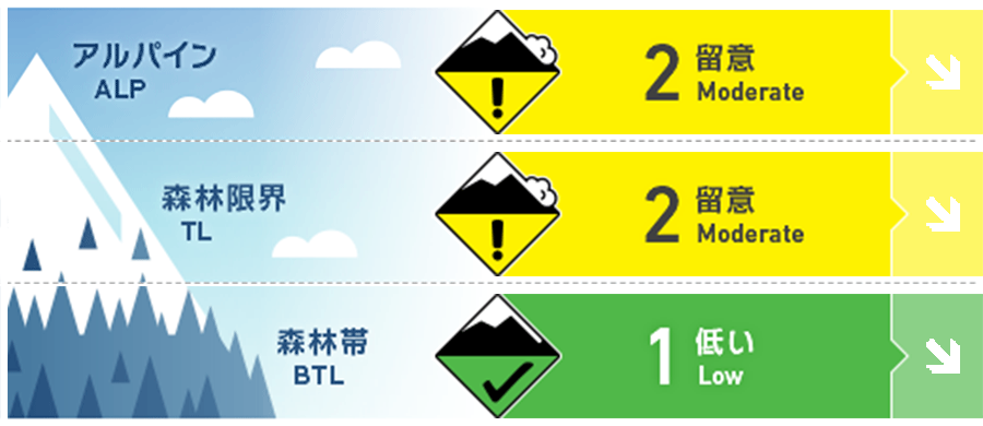
Niseko Yotei Yoichi Shiribeshi
Alpine Good Steep solar aspects will become a problem with day time warming and possible new precipitation Saturday night. 日射を浴びる急斜面では昇温に注意。また、土曜の夜には降雪となる予報が出ています。
Treeline Good Steep solar aspects will become a problem with day time warming and possible new precipitation Saturday night. 日射を浴びる急斜面では昇温に注意。また、土曜の夜には降雪となる予報が出ています。
Below Treeline Good Normal caution advised as day time temperatures warm the snow. 日中は昇温に伴う一般的な注意事項を考えてください。
信頼度:○ good □ Fair △ Low
Travel and Terrain Advice
As the snow softens and weakens with daytime warming, avoid steep solar aspects especially with terrain traps below. Avoid unnecessary time below large known glide avalanche paths especially when in unsupported terrain. 昇温と日射の影響で日中は積雪強度が落ちるため、斜面の下方に「地形の罠」がある南側の斜面は避けてください。また、自分の上方に地形が積雪を支えていないような斜面がある場合、全層雪崩の可能性が高まっているので、停留せず、素早く移動してください。
Avalanche Problem
全層雪崩 Glide slab


Glide avalanches are hard to predict when they will release. Avoid unnecessary time below large known glide avalanche paths especially when in unsupported terrain. 全層雪崩の発生予測は難しい領域にあります。地形的にサポートのない場所は、全層雪崩が発生しやすいところとなりますので、そうした場所は避けてください。
ストームスラブ Storm slab


If low elevation rain and wet snow in higher elevation falls Saturday night, storm slabs could form. This will only be a problem if forecasted precipitation falls. 土曜の夜から降雪が予報されており、高めの気温による降雪は、ストームスラブを素早く形成します。降雪の状況に注意を払ってください。
点発生湿雪雪崩 Wet Loose snow


Freeze thaw conditions where snow will be stable early morning and late afternoon. As the sun warms the snow rapidly with warm air temperature, loose snow slides expected on steeper than 35 degrees. 日中は融解して雪も、早朝と夕方には凍結し、安定した状態になります。日中は、35度以上の急斜面では昇温と日射で急速に積雪が強度を失う状態となりえますので、注意してください。
概要
Avalanche
A freeze thaw cycle dominates the stability of the snow. Likelihood of avalanches increase as the snowpack warms due to solar radiation and warm daytime air temperature. If new precipitation comes in Saturday night, windslab and/or storm slab problems could form. Glide avalanches become active in the spring especially during periods of warm weather. 積雪は融解凍結のサイクルにあります。結果、昇温や日射の影響で積雪が暖まり、強度を失うと、雪崩が発生しやすくなります。また、土曜の夜に降雪が予報されており、その際は、ストームスラブやウインドスラブの問題が発生しえます。全層雪崩は気温の高いタイミングで活動が活発になりやすい傾向があります。
Snowpack
Surface conditions vary widely. Ridge tops exposed to the northwest winds have been stripped down to hard crusts. Soft powder (surface faceted snow) can be found on steep sheltered north faces. Stiff wind packed snow in the alpine shaded aspects. Conditions will change throughout the day as the air temperature rises and the sun warms the snow. As the sun warms the snow , bonding will become weak. Under clear skies, as the sun leaves the snow, breakable crusts are expected. Deeper in the snowpack, weak snow can be found near crusts. These layers have not been linked to any reported avalanche activity. Under the crust, the snowpack is well consolidated. 雪面の状況は多様です。北西の風で削剥された稜線上は、硬いクラストが削られる、あるいは硬いクラストがそのままむき出しとなっています。アルパインエリアの日陰斜面では、ウインドパックされた硬い乾いた旧雪があります。積雪コンディションは、日中の気温上昇と日射で大きく変化します。よく晴れた日であれば割れやすいクラストなども形成されます。積雪のやや深いところでは、埋もれたクラストの周囲に結合力の弱い雪が観察されていますが、これらはこれまで報告された雪崩発生には関係していません。このクラストの下層はよく締まった安定した層となっています。
Weather
High pressure Saturday brings sun and mild daytime temperatures and light winds. A low pressure system south of Hokkaido strengthens and moves northeast late tonight bringing cloudy skies and a possibility of high elevation snow and lower elevation rain to the area. Cloudy skies and warm temperature expected for Sunday. 土曜日は高気圧に覆われるため、風も収まり、昇温が予報されています。北海道の南にある低気圧が発達しながら、今夜遅くに、北海道の北東に移動するため、くもり、その後、標高の高いところでは降雪、標高が低いところでは降雨が予報されています。日曜日はくもりながら、気温は高めの予報がでています。


