
雪崩情報
更新日時: 2021/12/09 07:00
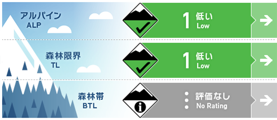
ニセコ・羊蹄・余市・尻別
アルパイン Good アルパインでは地形的な局所に小さいウインドスラブがありえます。It may be possible to find small pockets of Wind Slab in the alpine
森林限界 Good 南に向いた急斜面では、日射の影響を強く受ける時間帯で、濡れた雪の点発生雪崩がありえます。Steep south facing terrain could produce Loose Wet avalanches if exposed to extended periods of solar radiation
森林帯 Good 標高が低いところでは、雪崩を発生させるほどの十分な雪がありません。There is not enough snow at low elevations for avalanches to occur
信頼度:○ good □ Fair △ Low
行動と地形の助言
シーズン初め特有の危険な状態および変化あるコンディションでのスキーは、なかなか難しいものです。スキーやスノーボードをされる際は、そうした危険要素に十分に注意を払い、できればより十分な積雪量となるまで待つことが良い選択です。Early season hazards and variable conditions present challenging skiing. Ski or ride with caution and be patient as we wait for more snow to arrive.
留意すべき雪崩
点発生湿雪雪崩 Wet Loose snow


一年で一番日照時間が少ない時期を迎えていることもあり、日射が積雪を温める影響は小さく、濡れた雪の雪崩の可能性は低くなります。We are approaching the shortest days of the year so the impact of the sun on the snow surface is weak and is unlikely to provide sufficient warming to create loose wet avalanches.
ウインドスラブ Wind slab


移動可能な雪はとても少ないのですが、アルパインでは地形局所に小さいウインドスラブが形成しえます。Very little snow is available for transport however small pockets of wind slab may have formed in the alpine.
概要
雪崩
新しい雪崩の発生報告はありません。No new avalanches have been reported.
積雪
標高1,000m 付近までの雪面は融解凍結クラストが形成しています。その下層の積雪はよく焼結しており、再凍結したベースの上の載っています。総積雪深さは30~80 cm程度です。A melt freeze crust has developed on the snow surface up to 1000m. The lower pack is well consolidated and sits on a re-frozen base. Total season snowpack depth varies from 30-80cms.
天候
高気圧の影響は金曜の午後まで残ると予報されています。ただし、週末には低気圧が発達し、月曜には冬型の気圧配置に戻るとのことです。A high pressure system remains in the region until Friday afternoon. It will be pushed out by a weak low pressure system that will develop in intensity later in the weekend and a return to winter conditions by Monday.


