
雪崩情報
更新日時: 2021/12/23 07:00
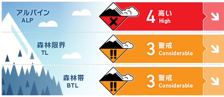
ニセコ・羊蹄・余市・尻別
アルパイン Fair 暴風と大量降雪が風下側に大きな負荷を掛けています。このまとまった降雪が落ち着くまで十分な注意を払う必要があります。Extreme wind and heavy snowfall have loaded leeward slopes. Exercise caution until the new snow has had a chance to bond to the old storm snow.
森林限界 Fair すべての斜面でスラブ形成の証拠を探す必要があります。Look for evidence of slab formation on all aspects at treeline.
森林帯 Fair 少雪であった森林帯でも雪崩を発生させるうるほどの積雪深となりました。The BTL zone now has enough snow for slab avalanches to be a concern.
信頼度:○ good □ Fair △ Low
行動と地形の助言
大量の雪の堆積がある大きな斜面は、積雪の不安定性が解消するまで避けてください。雪崩の危険は継続していますので、仲間を常に視界に入れた行動を取るなど、基本的な行動様式を大切にしてください。Avoid heavily loaded leeward slopes until they have had a chance to stabilize. Snow immersion hazard continues to be a serious concern so keep track of your friends even in non-avalanche terrain.
留意すべき雪崩
点発生乾雪雪崩 Dry Loose snow


急斜面には点発生雪崩の危険があります。Loose dry activity can be expected on steep slopes.
ストームスラブ Storm slab


森林限界付近では、強風から守られた場所にあるストームスラブの存在に特に注意が必要です。Storm slab may be lurking in protected areas below the treeline.
ウインドスラブ Wind slab


強風と大量降雪により、風下側の積雪は急速に増えています。自然発生の雪崩は荒天の最中に起きている可能性がありますが、移動可能な雪が多量にありますので、再配分された積雪によって、雪崩の危険は高いままです。Strong winds and heavy snow have rapidly loaded leeward slopes. Many natural avalanches may have already released during the storm but could have easily re-loaded.
概要
雪崩
12月21日、尻別岳の東斜面、標高1000m付近にて、サイズ1.5の雪崩が観察報告されています。A Size 1.5 avalanche released to ground at 1000m East aspect Shiribetsu on Dec. 21.
積雪
強烈な吹雪によって、過去24時間で40~60 cmの降雪がありました。これによって、過去1週間の降雪量は1 mを超えており、なおかつ新雪内のウイークインターフェイスも残っています。この一連の荒天の雪は、よく結合し安定した旧雪の上の載っています。積雪の全体構造は、下層の密度が高く、上層ほど低密度であり、順構造となっています。An intense storm has delivered another 40-60cms of new snow in the past 24 hours. The settled accumulation over the past week is now well over a meter with some interfaces in the storm layers. The storm snow forms most of the snowpack and sits on a well consolidated base. Overall the snowpack is right side up and rounding.
天候
激しい降雪は落ち着き、北西風による軽度な降雪と中程度の風が今日明日、予報されています。気温は全域で氷点下となり、金曜の夜から強い寒気が入り、気温は低下する見込みとのことです。The intense storm has passed but a steady NW flow will continue to bring lighter snowfall and moderate winds to the region today and tomorrow. Temperatures will remain below zero across the region and expected to drop further Friday night.


