
雪崩情報
更新日時: 2021/12/25 07:00
ニセコ・羊蹄・余市・尻別
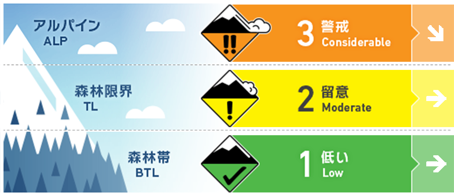
アルパイン Fair アルパインの不安定性は改善していますが、ウインドスラブが特定斜面に残っています。Alpine stability is improving but wind slab is present on leeward slopes.
森林限界 Good 荒天の雪の下層はよく沈降し、結合を強めています。しかし、上層部ではまだ雪崩を発生させうる状態です。Storm snow is settling and bonding to the lower pack but slab avalanches are still possible.
森林帯 Good この標高帯では、乾雪の点発生雪崩が主な注意事項となります。地形の罠を併せ持つ急斜面での滑走は十分な注意が必要です。Loose dry avalanches are the main concern at lower elevations. Use caution skiing or riding steep slopes above terrain traps.
信頼度:○ good □ Fair △ Low
行動と地形の助言
風下側となる地形には、新雪の下に以前のウインドスラブが隠れている可能性があるので、注意深くアプローチしてください。防寒対策をしっかりと行い、凍傷などにも注意を。メリークリスマス!Approach leeward features with caution as windslab may be buried just beneath the surface of the most recent snowfall. Bring extra warm layers and beware of cold injuries through this cold snap. Merry Christmas!
留意すべき雪崩
点発生乾雪雪崩 Dry Loose snow


とても急な斜面で乾雪の点発生雪崩がありえます。Loose dry avalanches can be expected on steep slopes
ストームスラブ Storm slab


低温はストームスラブをとても軟らかい状態に保っています。Cold temperatures will keep storm slabs very soft.
ウインドスラブ Wind slab


強風に曝されない、稜線より下がった場所にあるウインドスラブに注意してください。Look for windslab on protected features and just below ridge crest.
概要
雪崩
真新しい雪崩は報告されていません。No avalanche observations have been reported
積雪
金曜の夜からいくつかのエリアでは5 -15 cmの降雪がありました。この新雪の下層は、以前の荒天の雪によるもので、下層にいくに従い、焼結しています。12月14日の融解凍結クラストの下に、こしもざらめ雪が観察されており、トラッキングしています。この層は積雪の深い位置にあるため、雪崩を発生させるには大きな刺激が必要です。このクラストより下層は降雨の影響などもあり、安定しています。5-15cms of light dry snow fell overnight Friday night in some parts of the zone. This sits on ~1 meter of storm snow that is rounding and bonding to the lower pack. A thin layer of facets has been found in the lower pack below the December 14 Melt/Freeze crust. This layer is now buried deep in the pack and would require a heavy trigger to initiate an avalanche. Below this layer the base is a well consolidated re-frozen rain crust.
天候
気温は大きく低下し、麓の最高気温が-8℃、アルパインでは-20℃まで下がる予報です。土曜の日中は、弱い降雪と中程度の南風が予報されており、夜になると風雪が強まるとのことです。日曜も気温は低く、月曜の夜まで弱めの風と降雪が続く予報が出ています。Temperatures have dropped significantly with a high of -8C expected in the valley and alpine temperatures as low as -20C. Light snowfall with light to moderate SW wind is expected through the day Saturday with heavier snow Saturday night. Temperatures will remain cold Sunday with continued light wind and snowfall through until Monday night.


