
雪崩情報
更新日時: 2022/01/01 07:00
ニセコ・羊蹄・余市・尻別
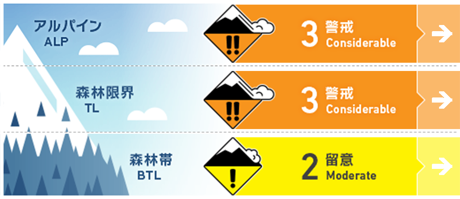
アルパイン Fair 本日、継続する降雪と明日の天候は新雪を落ち着かせる可能性がありますが、月曜日には再び、荒天の予報が出ており、これは雪崩の危険を押し上げます。Leeward slopes will continue to load through the day today before calmer weather prevails on Sunday allowing the new snow a chance to bond. A second storm system will increase the risk of slab avalanches on Monday.
森林限界 Good 新雪の下に危険なスラブが隠れている可能性があります。表層の雪で誘発された雪崩によって、この層までステップダウンすると規模の大きなものとなりえます。Look for indications of a cohesive slab buried below the new snow. If an avalanche steps down to this layer the consequences will be greater.
森林帯 Good 昨日、ストームスラブが人の刺激で反応しています。今日は、すべての地形で特別な注意が必要です。Storm slabs were reactive yesterday. Use extra caution on all terrain today.
信頼度:○ good □ Fair △ Low
行動と地形の助言
規模の大きな雪崩が発生しうる開放斜面へのアプローチは、とても慎重に行い、積雪が地形を支えないような斜面は避けるようにしてください。埋没している弱層は見つけにくく、状況が昨日よりも改善している可能性はありますが、もし、誘発した場合は雪崩の規模に大きな影響を与えます。次の雪崩情報は火曜日に発表されますが、月曜日には荒天となる予報がでています。まとまった降雪や強い風となった場合は、慎重に判断してください。Use caution approaching open terrain where large avalanches are possible and avoid skiing on unsupported slopes. The buried weak layer may be difficult to spot and more stubborn than it was yesterday however the consequences will be greater today. Another significant storm is expected Monday before the next forecast is due to be released on Tuesday. Evaluate conditions carefully if this storm brings heavy snow and strong winds as forecasted.
留意すべき雪崩
点発生乾雪雪崩 Dry Loose snow


とても急な斜面では乾雪の点発生雪崩が発生しえます。下方に「地形の罠」がある斜面に警戒してください。Loose dry avalanches can be expected on steep slopes. Use caution skiing above terrain traps.
ストームスラブ Storm slab


昨日はストームスラブが人的な刺激に反応しています。この24時間で状況は多少改善している可能性はありますが、スラブの強度が上がっているため、もし、誘発するとより大きなものが発生しうる状況です。Storm slabs were reactive yesterday. While bonding may have improved in the past 24 hours, the potential avalanche size is larger today as a result of the added load.
ウインドスラブ Wind slab


継続した風によって再配分された雪により、風下側にはウインドスラブが形成しています。Rapid loading and steady wind transport has caused wind slab to form on leeward slopes.
概要
雪崩
尻別岳、標高900m、南東斜面でサイズ1のストームスラブの雪崩が、12月31日に報告されています。誘発は偶発的なもので、怪我などはありません。Size 1 skier accidental Storm slab down 30cms @900m SE aspect Shiribetsu reported on Dec. 31 (no injuries) Size 1 skier accidental Storm slab down 20cms Nitonupurri West Aspect on Dec. 31 (elevation not specified) (no injuries) Size 1 skier accidental Wind Slab down 30cms @900m SE aspect of Misunosawa (no injuries)
積雪
雪崩発表区域に南側(ニセコ・羊蹄・尻別)では10- 30 cmの降雪ありましたが、北部(余市)ではかなり少ないものでした。この新雪は、上記の誘発雪崩で反応した20- 30 cmの荒天の雪の上に載っています。また、その下層は球形化が進んだ1 mほどの厚みをもった以前の荒天の雪があります。さらにその下層は、厚さ30 cmほどのレインクラストとなっています。The southern part of the region (Niseko, Yotei, shiribetsu) received 10-30cms of overnight snowfall while the northern part of the region (Yoichi) received considerably less. The new snow sits on a 20-30cm layer of storm snow that was reactive yesterday as noted in the avalanche observations above. Below this layer is ~1m of rounding and consolidating snow. At the bottom of the pack is a 30cm thick refrozen rain crust.
天候
北西の風は今日も継続し、土曜の夜から高気圧に覆われるまでの間、弱い降雪と低温が予報されています。日曜の夜には次の低気圧が接近し、月曜には再び、大雪となる予報が出ています。The NW flow will continue today bringing light precipitation and cold temperatures before a high pressure starts pushing into the region Saturday night. This will bring milder temperatures, light winds and no snow on Sunday until a new low pressure system establishes on Sunday night. Heavy snowfall and cold temperatures are expected again on Monday.


