
雪崩情報
更新日時: 2022/01/20 07:00
ニセコ・羊蹄・余市・尻別
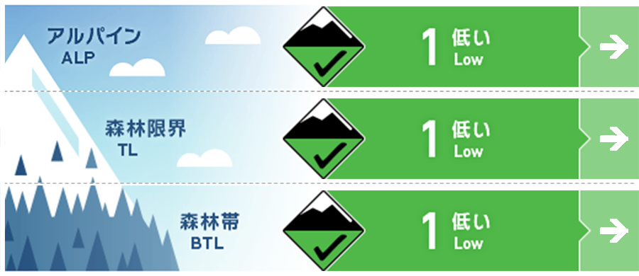
アルパイン Good 非常に急な斜面にて乾いた雪の点発生雪崩の可能性があります。Possible loose dry activity within the latest new snow in very steep terrain.
森林限界 Good 雪崩地形での通常の注意事項を考慮してください。標高の低いところでは、グライドクラックに注意してください。Regular terrain travel precautions to be taken. Watch for glide cracks that have opened at lower elevations.
森林帯 Good 雪崩地形での通常の注意事項を考慮してください。標高の低いところでは、グライドクラックに注意してください。Regular terrain travel precautions to be taken. Watch for glide cracks that have opened at lower elevations.
信頼度:○ good □ Fair △ Low
行動と地形の助言
バックカントリーの深いところまで探索するには最高のコンディションです。不安定な状況もほとんど報告されていませんし、私たちの観察でも見つかっていません。新雪の量は、この数日、少なくなっていますが、快適な滑走ができる場所はまだたくさんあります。安全な移動に必要な行動様式を続け、日陰の良いコンディションを探してください。標高600 m以下では、グライドクラックが拡大していますので、注意が必要です。Conditions are great to explore deeper into the backcountry. Little in the way of instability have been reported or found. New snow accumulation has been lower over the last few days but plenty of good turns can still be found. Continue proper safe travel techniques and the best conditions will be found in protected shaded areas. Be wary of glide cracks at lower elevations below 600m that continue to grow and open up creating clear hazards.
留意すべき雪崩
ウインドスラブ Wind slab


稜線付近では敏感に反応しないもののウインドスラブが存在しています。スラブの状態を確かめるようにしてください。Unreactive small pockets of soft wind slab have been found around ridgeline. Test areas where slab can be clearly identified.
点発生乾雪雪崩 Dry Loose snow


日陰のとても急な斜面では人の足元をすくう程度のサイズ1の雪崩が発生する可能性があります。そのような場所の下に入らないようにしてください。On shaded slopes the latest new snow may produce up to size 1 loose dry activity in very steep that would be enough to knock a single person off their feet. Manage the consequence of this possibility by not exposing yourself to clear hazards below you.
概要
雪崩
1月18日に、極めて急な地形でサイズ1の点発生雪崩が複数、観察されました。On the 18th multiple size 1(enough to knock you off your feet) loose dry avalanches were observed in extremely steep terrain although ski cuts produced no results.
積雪
積雪は引き続き、強度を上げており、不安定な要素はほとんど見当たりません。19日は日中の昇温と日射で急斜面ではスノーボールが発生していました。数日前に降った20 cmの新雪は、日陰斜面で低密度のままにあります。The snowpack continues to gain strength and little in the way of instabilities can be found. During the day on the 19th, solar aspects warmed with isolated roller balling occurring in steep terrain. The 20cm of new snow over the previous few days has remained of low density in the shade.
天候
現在、北海道は西に張り出した高気圧の端に位置しています。このため北風も弱く、日差しもある曇りの予報です。金曜日には、日本海なる雪雲が上陸し、北側では降雪量が多く、南側ではそれほど多くならない模様です。Currently, Hokkaido sits on the edge of a high-pressure system that stretches far to the West. The result of this is a Northerly flow bringing low winds and broken sunshine on Thursday. Friday may see the snow bands currently running down the coast in the Sea of Japan making landfall and bringing higher new snow totals in the Nothern part of the range whilst the Southern end will expect less accumulation.


