Avalanche Bulletin
更新日時: 2022/12/31 06:00
Hakuba
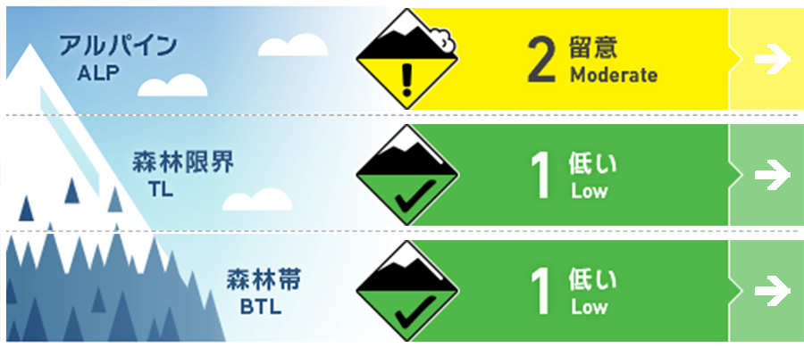
Alpine Low
Treeline Fair
Below Treeline Good Do not enter around glide cracks, especially downward.
信頼度:○ good □ Fair △ Low

Travel and Terrain Advice
A mild day is forecasted. If you going to the high elevation, you should be aware of wind slabs that are forming locally. No matter what type of avalanche, the most effective way of avalanche safety is to reduce the slope angle. Start using slopes with a slower slope and enjoy the day with caution. Also, the snowpack is thin, the bushes are thick, and the gully is narrow and has holes in it. Make an effort to stay up-to-date. Thank you for your support this year. Wishing you all a happy new year.
Avalanche Problem
ウインドスラブ Wind slab


Pay attention to the wind's effects on the snowpack.
ストームスラブ Storm slab


There is variation in the bond strength between new snow and old snow.
概要
Avalanche
Yesterday (30th), a glide avalanche of size 1-1.5 was observed on a steep south-facing slope in the lower treeline elevation. In addition, a slab avalanche triggered by ski patrol has been observed during the safety management.
Snowpack
The snowpack brought by the snowfall of the past few days has settled steadily below treeline. Above the treeline, the conditions were softly accumulated without much influence from the wind. At higher elevations, such as the main ridge line, and in areas that are in the path of the wind, the wind has been redistributed to the leeward side, influenced by northwest to westerly winds.
Weather
The Japan Meteorological Agency is forecasting that a winter pressure pattern will continue over northern Nagano Prefecture, but that the area will be affected by a trough and cold air, with cloudy and sometimes sunny skies, some snow along the mountains and in the Nakano Iiyama area, and a daytime maximum temperature of 5°C. At the foot of Mt. Hakuba (elevation 703m), the temperature is -5.1℃ (as of 5:00), with little new snowfall at the foot of the mountain.

