
雪崩情報
更新日時: 2021/02/20 06:17
ニセコ・羊蹄・余市・尻別
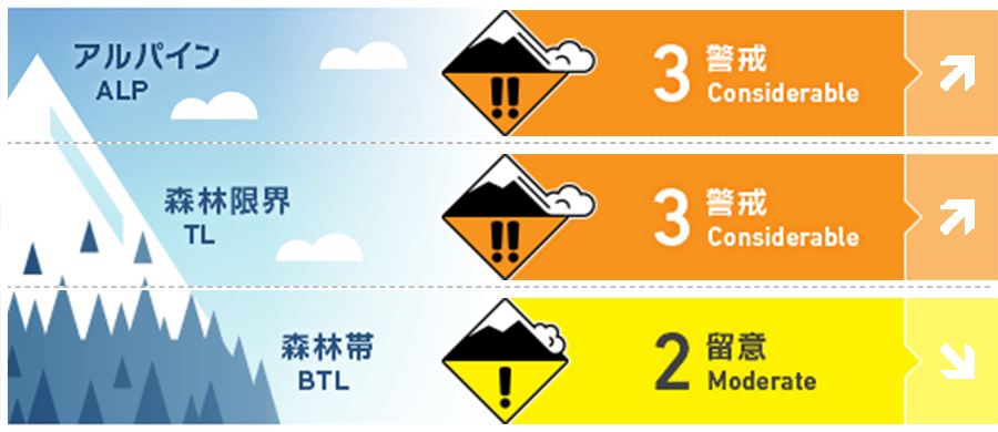
アルパイン Fair Expect wind slab to form on North aspects today. As the wind shifts to the West, more complex loading patterns can be expected. 北面でのウインドスラブの形成に注意。風向が西へと変わると、状況はより複雑となります。
森林限界 Fair Wind slab and storm slab problems will increase as more snow arrives through the weekend. 週末の降雪が、ストームスラブとウインドスラブの問題を増大させます。
森林帯 Good Rain at lower elevations has lubricated the snowpack. 標高が低いところでは、降雨が積雪に影響を与えています。
信頼度:○ good □ Fair △ Low
行動と地形の助言
Be cautious of rapid wind slab development and increasing hazard from the storm slab as new snow arrives in the region. 急速に発達するウインドスラブと、降雪と開始と共にストームスラブの危険の上昇に注意を。 Avoid travel near glide cracks until temperatures have dropped well below zero for an extended period of time.
留意すべき雪崩
点発生湿雪雪崩 Wet Loose snow


Loose wet avalanches can be expected on steep slopes at lower elevations until temperatures drop below zero late Saturday afternoon. 気温が完全に氷点下に下がるまで、標高の低い場所では、濡れた雪による雪崩の可能性があります。
全層雪崩 Glide slab


As the rain and warmer temperatures lubricate the snowpack, glide cracks will open up on steep slopes and below convexities. Full depth glide avalanches remain unlikely however high consequence if they do occur. Avoid travel below glide cracks until temperatures have dropped below freezing. 降雨と昇温によって、急斜面や凸状下部にあるグライドクラックは、より開きます。既に開いている深いグライドクラックは、すぐに雪崩発生する可能性が低くとも、もし、それが起きた場合、とても重大なものとなります。気温が氷点下に下がるまで、グライドクラックの下の通過は避けてください。
ストームスラブ Storm slab


Upper elevations have received new snow overnight while lower elevations received rain. By the end of day Saturday temperatures will be below freezing at all elevations while new snow continues to arrive until the end of the weekend. Bonding of the new snow may be suspect particularly at lower elevations where a crust will develop after the rain stops. 標高の高いところでは、昨晩から降雪となり、標高の低いところでは雨となりました。天気予報によると、本日夕方にはすべての標高帯で気温は氷点下になるとのことです。標高の低いところでは、降雨で濡れた雪面が凍結し、その後、新雪が載りますので、その境界面に注意を。
ウインドスラブ Wind slab


Strong southerly winds over the last 12 hours have loaded North aspects. As the wind shifts to the West, watch for wind slab development on East aspects as well. 過去12時間において、強い南寄りの風によって、北側に雪が移動しています。この後、風向が西へ変わりますので、東側の斜面においても、ウインドスラブに対する警戒が必要となります。
概要
雪崩
Size 1.5 Natural release windslab avalanche reported at 1000m on a South aspect of Shiribetsu on Friday Feb. 19 2月19日、尻別岳、南面、標高1000mにて、size 1.5のウインドスラブの雪崩が、自然発生していたことが報告されています。 Size 3 Wet slab avalanche debris observed earlier in the week on South aspects likely occuring naturally during the rain event on Tuesday Feb. 16
積雪
Heavy rain on Tuesday Feb. 16 was followed by 48 hours of heavy snowfall totaling approximately 60cms across most of the region. Warmer temperatures Friday allowed this storm snow to settle significantly before light precipitation arrived again on Friday night. This warmer storm has brought new snow to the alpine and rain to lower elevations. 2月16日(火)にまとまった雨が降り、その後、48時間で、この地域には概ね60cm程度の降雪がありました。19日(金)に気温が上昇したため、この荒天の雪は沈降を進め、落ち着いてきましたが、再び、昨晩、小雨が降っています。この暖かい空気をもった荒天は、標高が高いところでは、新たな降雪をもたらしています。
天候
An approaching low pressure system is currently drawing warm moist air from the SW. As it moves to the North of Hokkaido through the day on Saturday, a NW flow will resume bringing cooler temps and snow Saturday night. Rain is expected at low elevations Saturday morning before temperatures drop and precipitation turns to snow. Freezing level will rise to 450 meters before dropping back to sea level by the end of the day. Snow is expected overnight Saturday night as NW flow returns. 低気圧が接近しており、南西から暖かい湿った空気が流れ込んでいます。天気予報によると、本日の昼に北海道の北側を移動するため、夕方には、気温が下がり、北西の風と共に降雪が始まるとのことです。本日の午前は降雨が予報されており、凍結高度は450mまで上昇しますが、その後、海面レベルまで戻る予測がでています。冬型となり、北西の風と共に、本日夜から降雪となる見込みです。


