
Avalanche Bulletin
更新日時: 2022/01/11 06:00
Niseko Yotei Yoichi Shiribeshi
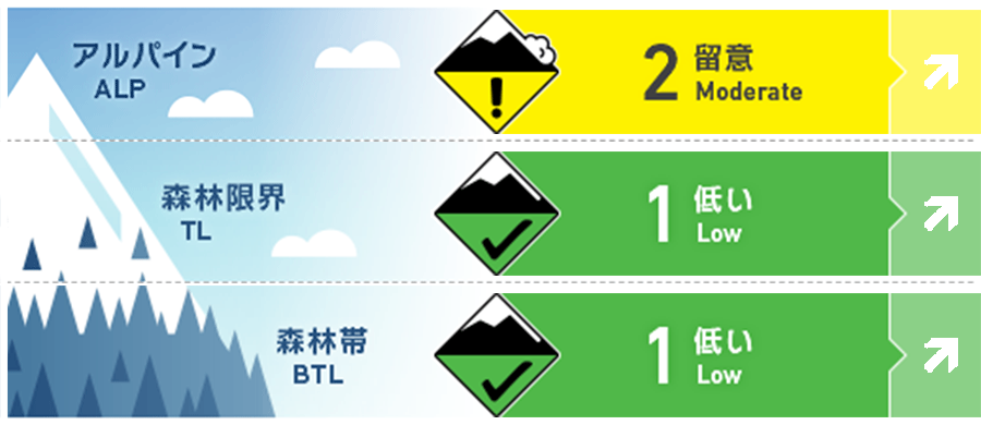
Alpine Good 現在、稜線や岩稜直下の孤立した地形ポケットに小さいスラブがあります。今後48時間で大量降雪が予報されており、それに伴い、雪崩危険度も上昇します。この変化に注意が必要です。Currently, small pockets of slab may be found in isolated terrain below ridgelines or rock features. These conditions are expected to change during this forecast period as we see increased wind and snowfall totals over the next 48 hours. The danger rating will increase in the coming days.
Treeline Good 森林限界付近では、現在、不安定な要素はほとんどありません。今後、現在の雪面と新たな降雪の関係を注視する必要があります。Little in the way of instability is currently found at mid-elevations. The relationship between the current snow surface and the new snow will be a key focus in the coming days.
Below Treeline Good 予想される荒天で降雨となった場合、既にグライドクラックが入った急斜面や、明らかな地形の罠があるような場所には近づかないようにしてください。If we receive rainfall at the onset of the coming storm system avoid any time below glide cracks or steep angled terrain with obvious terrain traps.
信頼度:○ good □ Fair △ Low
Travel and Terrain Advice
Sudden changes in weather are forecast within the next 48 hours. If you're heading out into the backcountry, make it your goal to get back in your car before the weather gets worse. Particular attention should be paid to glide cracks that have recently had a reaction, especially if there has been rainfall at low elevations. Weather condtions will change rapidly throughout the next 48 hours. If planning on traveling into the backcountry make the goal to be back to the car beofore Being exposed to the inevitable weather event coming. Be wary of glide cracks that have been reactive recently especailly if we see rainfall at lower elevations.
Avalanche Problem
ウインドスラブ Wind slab


東側の特定の地形ポケットでウインドスラブへの注意を。風で圧縮されたようなキレイな雪面に注意し、滑走場所を選んでください。Pockets of winds slab may be found at higher elevations around specific features across the Easterly half. Look for smooth wind-pressed new snow and be wary of high consequence areas.
概要
Avalanche
On January 10, an observation of a Glide avalanche was reported on the eastern slope of the Moiwa district at an altitude of 750 m through SNS. Via social media, a report of a glide crack releasing the full seasonal snowpack in the The Mowia area was recorded on the 10th of January. This release was observed on an Easterly aspect at 750m.
Snowpack
The intensity of the snow cover is increasing due to the calm weather, weak winds, and rising temperatures over the past few days. As a result of snow accumulation observations at different elevations and multiple directions, there is little instability. However, due to weather forecasts, this situation is expected to change drastically in a few days. Settled weather over the last few days combined with reduced wind speeds and warm temperatures has resulted in the snowpack gaining strength. Multiple snow pit results on various aspects and elevations have seen little in the way of instability. This is expected to change in the coming days with the current forecast.
Weather
The pressure arrangement of the winter type has strengthened, and it is forecast that the weather will be stormy from the middle of the week. The low pressure will pass on Tuesday, so southerly winds will intensify, and rainfall is expected to be lower than the below treeline. It is forecast that it will change to northerly winds on Wednesday, and snowfall will increase rapidly along with the northwestern storm. East of Japan pressure systems are stacking up that will create blizzard conditions in the middle of the week. After multiple days of more settled weather, a low-pressure system will hit landfall on Tuesday bringing a Southerly flow and the potential for rainfall below treeline early in The storm. Into Wednesday, a Northerly shift will occur and snowfall will increase rapidly alongside Gale to Extreme Gale North Westerly winds.


