
Avalanche Bulletin
更新日時: 2022/03/18 06:00
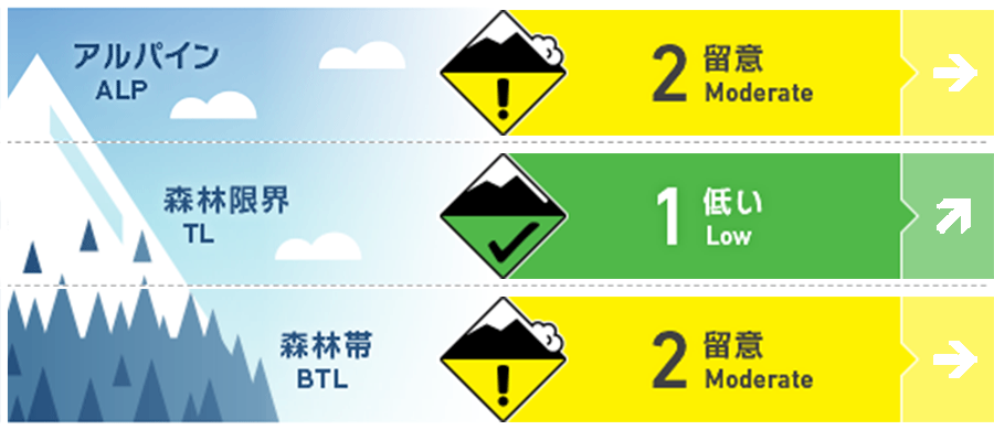
Myoko
Alpine Low 今後の降雪強度に留意
Treeline Low 今後の降雪強度に留意
Below Treeline Fair 降雨となっている標高帯にて
信頼度:○ good □ Fair △ Low
Travel and Terrain Advice
Pay attention to the intensity of the upcoming snowfall. Snow with weak binding force is resting on the hard snow surface, so it is necessary to pay attention to long-legged point avalanches on steep slopes where edges and crampons do not work well, or steep slopes where the amount of fresh snow has increased. Also, be wary of Glide avalanche in places with low elevations where rainfall occurs. Please stay away from slopes with glide cracks. The weather is clearly going downhill. An action plan that takes that into account
Avalanche Problem
点発生乾雪雪崩 Dry Loose snow


今後の降雪強度に留意
全層雪崩 Glide slab


降雨となっている標高帯にて
概要
Avalanche
Yesterday (17th), a point-generated wet snow avalanche of size 1-2 or a full-layer avalanche was observed in the below treeline.
Snowpack
At high altitudes, the strength of the snow cover surface layer was maintained by strong winds, but as the elevation lowered, the snow became wet. The rainfall or snowfall from this morning here is listed. Slopes with glide cracks are decreasing in strength due to high temperatures every day, so it is necessary to be especially vigilant against Glide avalanche in the elevation zone where rainfall occurs.
Weather
The Japan Meteorological Agency predicts northeastern wind, rain, and high temperatures of 7 degrees Celsius (elevation 13 m) for the Joetsu region of Niigata prefecture. The temperature is 0℃ (as of 5:00) at Myoko Sasagamine (elevation 1,310m).