
Avalanche Bulletin
更新日時: 2023/11/23 07:00
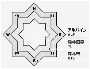
Tateyama
Alpine Good
Treeline
Below Treeline
信頼度:○ good □ Fair △ Low

Travel and Terrain Advice
It is recommended that you adhere to the behavioral principle of not staying in avalanche start zones, tracks, or runout zones for long periods of time. The areas near the higher-elevation ridges, which are more susceptible to wind, are hard and icy. Be careful of slips and falls. Many "terrain traps" such as rocks and gullies are exposed where even a small avalanche can cause extensive damage. Be careful of crashing into rocks thinly concealed by the snowfall. Weather conditions are forecast to worsen. Please be aware of the effects of wind, solar radiation, and other weather conditions.
Avalanche Problem
ストームスラブ Storm slab


Note the instability that remains locally on extremely steep slopes.
概要
Avalanche
Yesterday (22nd) during the day, there were reports of several naturally occurring wet loose snow avalanche size 1-1.5 observed from a southerly slope at a lower elevation.
Snowpack
Past storm snow has settled well and bonded well. Yesterday, the lower elevation southerly steep slopes melt-froze, and a simple fracture line survey of the avalanche triggered on the evening of the 21st was conducted, but no significant fragility was observed on the ice sheet on the bed surface; the effect of faceting on the ice sheet remains in areas where the snowpack is thin near 2600 m; the ice sheet is still in a state of recrystallization; the ice sheet is still in a state of recrystallization at the lower elevation of the avalanche, and the ice sheet is still in a state of recrystallization at the lower elevation of the avalanche; the ice sheet is still in a state of recrystallization at the lower elevation of the avalanche, but the ice sheet is not in a state of recrystallization at the lower elevation of the avalanche.
Weather
The temperature at 2380m as of 6:00 am was 2.9°C, with strong winds blowing from the west to the south. According to the Japan Meteorological Agency, high pressure is expected to cover the area, but low pressure is expected to move from near Primorsky Krai to near Sakhalin, and a cold front is expected to move southward across the Sea of Japan and approach the Hokuriku area, resulting in cloudy skies at the foot of the mountains and occasional sunshine until late afternoon, with some rain and thunderstorms in the late evening.