
Avalanche Bulletin
更新日時: 2024/01/13 05:30
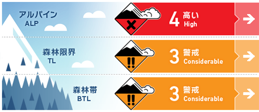
Hakuba
Alpine Fair
Treeline Fair
Below Treeline Fair
信頼度:○ good □ Fair △ Low
Travel and Terrain Advice
Strong winds and snow are forecast to continue until noon. Very careful route selection and conservative decision making is required. When visibility is poor, it is difficult to notice hazardous elements above you. Consider whether there are any major start zones. Snowpack is increasing, but is still low compared to the usual season. Be very careful in the forest, as there are hidden danger traps other than avalanches (holes in stream bottoms, etc.). For less experienced groups, today is a good day to enjoy the powder snow inside the ski area. If you do so, please observe the boundary ropes. It is important for your safety as well as the safety of the other guests. Have a safe and good day.
Avalanche Problem
ストームスラブ Storm slab


概要
Avalanche
Yesterday (12th), a size 1 loose snow avalanche was observed on the northern slope below treeline.
Snowpack
A new snowfall cycle that began on the morning of the 12th brought about 30 cm of new snow (around 1,300 m elevation). This new snow is on top of wind slabs on the eastern slopes at higher elevations. On the other hand, on slopes where the wind influence is weaker and the sun has no effect, the new snow is on top of less cohesive snow.
Weather
The Japan Meteorological Agency is forecasting northerly winds, snow, and a daytime high of 1 °C (418 m elevation) for northern Nagano Prefecture. At Amedas Hakuba (elevation 703 m), the temperature is -1.4 °C (as of 5:00 a.m.), with 6 cm of snow having fallen in the past 12 hours. The Nagano District Meteorological Office, in its forecast for heavy snow at 4:41 a.m. on the 13th, is predicting 60 cm of snowfall in 24 hours until 6:00 a.m. on the 14th.
