
Avalanche Bulletin
更新日時: 2024/02/12 05:30
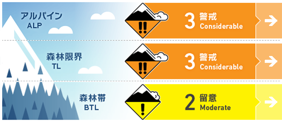
Hakuba
Alpine Fair Even if the weather improves, be on the lookout for wind slabs.
Treeline Fair Even if the weather improves, be on the lookout for wind slabs.
Below Treeline Fair
信頼度:○ good □ Fair △ Low
Travel and Terrain Advice
Forget yesterday's fun riding, today is a day to consider the snow conditions with a new mindset. A very strong westerly wind is starting to blow on the main ridge, so please be on the lookout for its effects. On the south face, crusts formed yesterday, and on the north side, on top of the dry snow, snowfall up to this morning is accumulating under the influence of the wind. There are many things to pay attention to, such as whether there are any large start zones above you, whether the terrain is convex enough to make it difficult to support the snowfall, and whether shooting cracks have developed while you are walking. Visibility is poor in the morning, making situational awareness difficult. Please use good communication with your companions and conservative route setting and careful terrain selection.
Avalanche Problem
ウインドスラブ Wind slab


Strong westerly winds up to 20 m/s have begun to blow on the main ridge since early morning. Be on the lookout for new wind slabs formed by the snow moved by this wind. Be careful not only of simple downwind slabs, but also of wind slabs that have formed on the flanks of tributary ridges and gully terrains.
ストームスラブ Storm slab


Be alert for steep slopes with more snow accumulation due to winds.
概要
Avalanche
Yesterday (11th), during morning safety control at the ski area, a number of size 1-1.5 storm slab avalanches were reported on the southeast to northeast slopes. In the mountain area, several size 1.5-2 slab avalanches were observed on the southeast slope of the alpine area. All were spontaneous. Shooting cracks were also reported in areas where windy snow had accumulated. On the other hand, size 1 loose snow avalanches of size 1 were observed at very low elevations.
Snowpack
Snowfall since midday on the 10th has been around 60 cm in the northern part of the Hakuba Valley and 30 cm in the southern part, and ended yesterday (the 11th). The issue of surface hoar instability, which had been a concern as of yesterday, was not found to be a problem at this time based on several observations. On the other hand, there were areas of weak bonding within the new snow, showing a response to human stimulation. Higher temperatures and solar radiation have promoted settling on the south face, but kept the north face dry. From earlier today until this morning, about 10 cm of snow fell in the upper part of the Below Treeline.
Weather
Today, the area will be affected by a pressure trough and cold air at first, but will gradually be covered by high pressure. The Japan Meteorological Agency is forecasting northerly winds, clear skies, snow until dawn, and a daytime high of 6 °C for northern Nagano Prefecture. At 703 m elevation in Hakuba, the temperature is -3.9 °C (as of 5:00 a.m.).
