
Avalanche Bulletin
更新日時: 2024/02/13 05:30
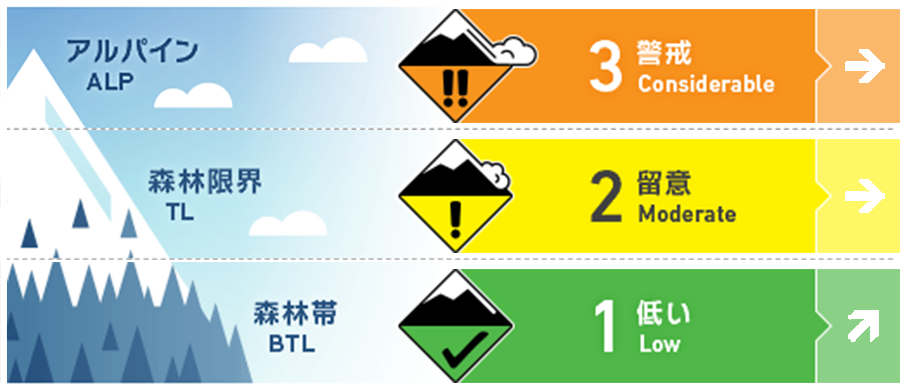
Hakuba
Alpine Fair
Treeline Fair
Below Treeline Fair Note the effects of elevated temperature and solar radiation.
信頼度:○ good □ Fair △ Low
Travel and Terrain Advice
Overall, consider that the same trend as the previous day is continuing. The higher elevations are more affected by the wind, and wind slabs are forming. The wind direction changed last night, so we need to be on the lookout for new slabs. Also, the instability within the recent snowfall has not been completely eliminated, so please observe the terrain carefully and choose simple slopes without "terrain traps". On steep south-facing slopes at lower elevations, where the effects of solar radiation and rising temperatures are stronger, watch for changes in snow during the day. If snowballs due to wet snow begin to form, this is a sign of danger. Keep an eye on slopes above you. This is a great day for great weather. Bring sunscreen and plenty of water. Have a great day.
Avalanche Problem
ウインドスラブ Wind slab


Wind direction is shifting from west to southwest. Be alert for the formation of new slabs. Hard slabs that have formed on steep south-facing slopes may reduce in intensity and increase in skier-triggered sensitivity due to the effects of rising temperature and solar radiation. Do not rely on your judgment in the morning.
ストームスラブ Storm slab


As winds weaken, watch out for steeper slopes where more wind-drifted snow is deposited. Even if a clear wind slab has not formed, there are still areas of weak bonding within the recent snowfall. Instability increases when large loads are applied there.
概要
Avalanche
Yesterday (12th), several size 1.5-2 wind slab avalanches and shooting cracks were reported in the alpine area. Several triggered size 1 storm slab or loose snow avalanches were also reported at slightly lower elevations.
Snowpack
Within the new snow that has fallen only at relatively high elevations since the 10th, there are areas where sintering has not yet fully developed, and wind slabs are placed on these areas, resulting in multiple avalanches yesterday. Consider the same trend continuing today. In addition, the forecasted significant temperature increase began late yesterday night, with temperatures rising to around -5°C at the main ridge line and the wind direction changing to the southwest.
Weather
The Japan Meteorological Agency is forecasting a southerly wind, later northerly wind, clear skies, and a daytime high of 13 ºC for northern Nagano Prefecture. At 703 m elevation (Hakuba), the temperature is -9.0 °C (as of 5:00), with no new snowfall in the past 12 hours.
