
Avalanche Bulletin
更新日時: 2024/02/15 07:00
Niseko Yotei Yoichi Shiribeshi
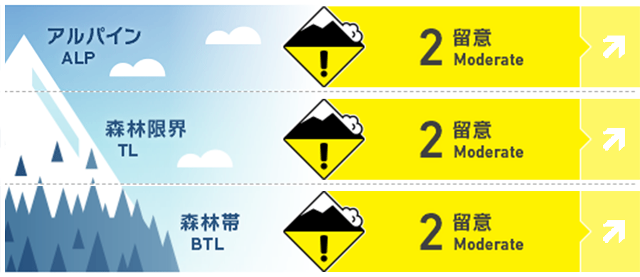
Alpine Good Low hazard can be expected in the BTL until new snow arrives Thursday night. The hazard will increase to moderate with the arrival of new snow.
Treeline Good Low hazard can be expected in the TL until new snow arrives Thursday night. The hazard will increase to moderate with the arrival of new snow.
Below Treeline Fair Low hazard can be expected in the BTL until new snow arrives Thursday night. The hazard will increase to moderate with the arrival of new snow.
信頼度:○ good □ Fair △ Low
Travel and Terrain Advice
Surface snow has re-frozen causing backcountry travel to be hazardous and challenging until we receive new snow. Once the new snow arrives it will need time to settle and bond to the widespread melt/freeze crust.
Avalanche Problem
ウインドスラブ Wind slab


Moderate snowfall Thursday night accompanied by light NW winds will cause windslab to form on leeward slopes. The slab will form over the melt/freeze crust established during the recent temperature spike which will provide a good sliding surface and likely reactive to skier traffic tomorrow (Friday).
ストームスラブ Storm slab


Moderate snowfall Thursday night will land on re-frozen surfaces. If storm slab forms, it will be reactive to skier traffic.
点発生乾雪雪崩 Dry Loose snow


Following the arrival of new snow tonight, Dry Loose avalanches can be expected to run on steep slopes.
全層雪崩 Glide slab


Freezing levels have dropped back down however moisture from the recent temperature spike continues to percolate through the snowpack meaning that glide cracks and glide avalanches remain a concern.
概要
Avalanche
Widespread Wet loose cycle and cornice failures occurred across SW Hokkaido during the recent temperature spikie. A size 2.5 Natural avalanche was observed on NE Yotei on Tuesday Feb. 13th during a period of strong wind. The trigger was not observed and no involvements were reported. Another size 2 Natural cornice trigger avalanche occurred on SW Yotei during the temperature spike (time of occurence unknown).
Snowpack
Warm temps penetrated 10-15cms of the upper snowpack creating moist snow surfaces on all aspects up to 1100 meters during the warm event. Cooling temps will cause this to re-freeze creating a frozen surface for the next snowfall to land on. Lower pack is well settled and is now tightening as temperatures drop back down.
Weather
Today brings a returng to more seasonal temps with freezing levels returning to sea level. Expect mostly overcast conditions through the day with the occasional light flurry in some parts of the region. Heavier snowfall is expected overnight Thursday with accumulations of 5-20cms expected by Friday morning. Temperatures will drop steadily through the day today and tomorrow with Light NW winds throughout this period. Snow will taper off tomorrow with a chance of the occasional sunny break mixed in with light snow flurries.


