
Avalanche Bulletin
更新日時: 2024/02/16 06:00
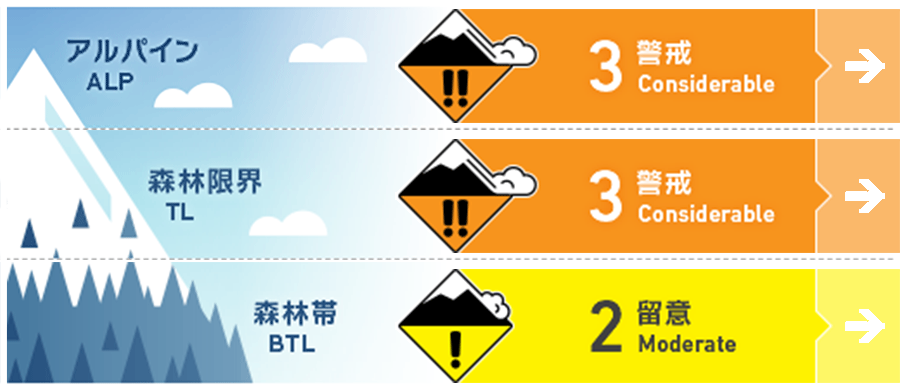
Myoko
Alpine Low
Treeline Low Evaluation centered on the north side where snowfall was heaviest.
Below Treeline Fair
信頼度:○ good □ Fair △ Low
Travel and Terrain Advice
At higher elevations, watch out for instability caused by the fresh snow that has fallen so far this morning. Underneath the new snow is a hard, frozen slope, a situation that can lead to a slip down, even if it triggers a small avalanche. If there are elements of a "terrain trap" below the slope, such as cliffs, trees, or rocks, the consequences can be serious. Continue to follow basic safety behaviors such as stopping at a safe place and spacing people out in dangerous areas. Also, at very low elevations, the danger of glide avalanche continues. Stay away from slopes with glide cracks.
Avalanche Problem
概要
Avalanche
Numerous size 1 wet loose snow avalanches were observed yesterday (15th). Several size 1-2 glide avalanches were also reported.
Snowpack
The snowpack was wet from yesterday's (15th) rainfall, frozen hard in the higher elevations due to the cold nighttime temperatures, and still wet in the lower elevations. Late last night, a winter pressure pattern formed, but due to the weak cold air, snowfall occurred only at higher elevations. Snowfall was heaviest in the north and northwest of the mountain range, with about 30 cm near the treeline.
Weather
The Japan Meteorological Agency is forecasting slightly strong northwest winds, snow or rain, cloudy from early afternoon, and a daytime high of 4 °C (13 m elevation) for the Joetsu region of Niigata Prefecture. At Sasagamine, Myoko (elevation 1,310 m), the temperature is -5 °C (as of 4:45 a.m.), and 3 cm of snow has fallen in the past 12 hours.