
Avalanche Bulletin
更新日時: 2024/02/22 06:00
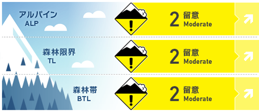
Niseko Yotei Yoichi Shiribeshi
Alpine Fair Continued snowfall and winds strong enough to transport snow for windslab development in the alpine. Fair confidence due to some areas in the north around Otaru potentially receiving more snow and stronger winds for more windslab development and sensitivity.
Treeline Good Windslab development at treeline from continued snowfall and winds strong enough for windslab development on slopes lee to the wind at treeline ridge tops and ridge top like features.
Below Treeline Good New snow in sheltered areas below treeline will cause concern for loose dry on steeper aspects.
信頼度:○ good □ Fair △ Low
Travel and Terrain Advice
Challenging touring conditions will exists on steeper aspects from the crust that lies below the new snow. Ski crampons could be a good tool to carry along if possible. Glide cracks are continuing to open and will need attention and caution in route planning. It is best to avoid re-groups near and especially below glide cracks. Extra caution on open slopes in the alpine and at treeline for windslab. This forecast extends to Saturday morning.
Avalanche Problem
ウインドスラブ Wind slab


Windslab development observed at treeline and above. The windslab sits on top of an icy bed surface that will have poor bonding.
点発生乾雪雪崩 Dry Loose snow


Sheltered areas below treeline has a very strong crust and will be a slippery surface for the fresh snow to slide on.
概要
Avalanche
Loose dry avalanches observed during this recent storm cycle. Windslab development has been observed at treeline and above in the last two days and will continue to become hazardous with more snow and wind that is on top of an icy surface. Storm slab development and sensitivity will need more assessment and will depend in part on snowfall amount.
Snowpack
The lower part of the snowpack is mostly settled, however it is the upper snowpack that will need continued assessment. There lies a hard crust in the upper snowpack that is now getting buried by new snow. For one the crust provides a surface for poor bonded new snow to slide on and two, weak layers around the crust may form. The crust has been prevalent on all aspects and elevation bands in the forecasted region.
Weather
Continued northwest flow for the forecast region bringing steady snowfall with more snow forecasted near Otaru. The northwest winds will continue as mostly moderate today and decrease a bit tomorrow. Temperatures will remain well below freezing at sea level.


