
Avalanche Bulletin
更新日時: 2024/02/23 04:00
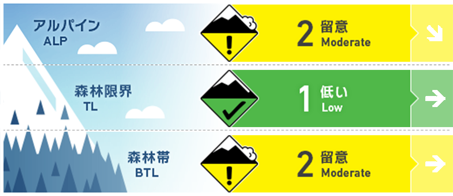
Kagura Tanigawa Hotaka
Alpine Low Snowfall amounts are unknown.
Treeline Fair Not much information.
Below Treeline Fair Unknown impact of past rainfall
信頼度:○ good □ Fair △ Low
Travel and Terrain Advice
At lower elevations, conditions are expected to remain, which were affected by yesterday's cooler nighttime temperatures and rainfall. Be aware of the possibility of glide avalanches from open cracks and steep cliff-like slopes. We recommend that you stay clear of the lower part of such areas and the gully bottom, or pass through them quickly. Be careful about falling into gully as well. Be aware of extreme steep storm slab bonding at higher elevations.
Avalanche Problem
全層雪崩 Glide slab


Beware of open cracks and steep cliff-like slopes.
ストームスラブ Storm slab


Beware of extremely steep slopes
概要
Avalanche
Yesterday (22nd), there was a report of a glide avalanche size 2 observed on the northwest slope at 1100m elevation that occurred within the past 2 days.
Snowpack
The upper part of the snowpack has formed crusts, and bonding is expected to be good with about 5-10 cm of new snowfall on top of the crusts. There are no reports of vulnerability in the middle to lower layers of the snowpack. The surface crusts are still forming at lower elevations, but the lower part of the snowpack is expected to be wet and less strong due to the five days of cold nighttime temperatures until yesterday.
Weather
As of 4:00 pm, the temperature at Amedas Fujiwara is -1.1°C. There was 9 cm of snowfall in the past 24 hours, but settling has progressed. Weak snowfall is continuing at present. The Japan Meteorological Agency is forecasting that the front will move south of Honshu but will be affected by a pressure trough and moist air, so it will be cloudy and rain or snow will fall in some areas until early afternoon.