
Avalanche Bulletin
更新日時: 2024/02/27 05:30
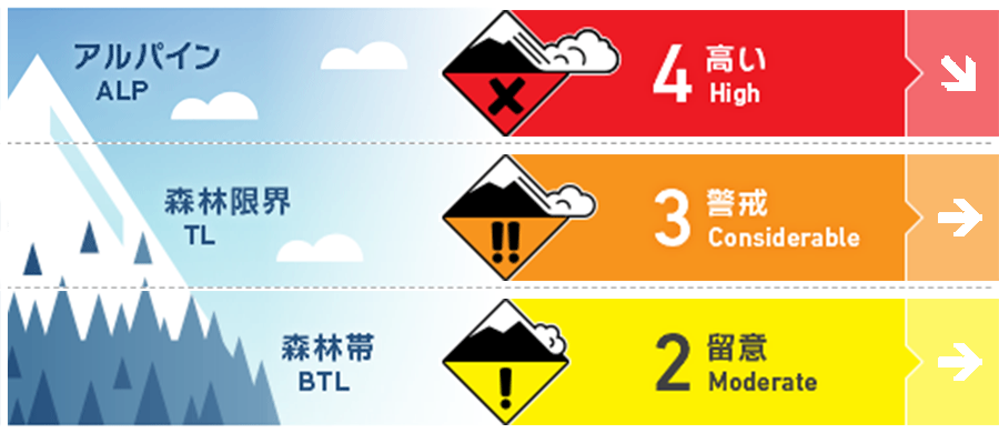
Hakuba
Alpine Fair
Treeline Fair
Below Treeline Fair
信頼度:○ good □ Fair △ Low
Travel and Terrain Advice
Be alert for wind slabs formed by strong winds. Wind slabs can form on the sides and flanks of trails on ridges, as well as large ones that spread across the entire slope. It is common for climbers to trigger a wind slab avalanche when they turn slightly to the downwind side to avoid the rocks and wind. In the northern areas of the Hakuba Valley where there has been heavy snowfall, be more alert for both wind slab and storm slab. Please consider whether there are any large start zones above you and manage your group wisely using safe terrain. Besides avalanches, this is a day of severe weather conditions. Inexperienced groups are encouraged to enjoy the ski area.
Avalanche Problem
ウインドスラブ Wind slab


Strong winds are blowing northwest to north on the main ridge and northerly at lower elevations. Even below treeline, extreme caution should be exercised on slopes where wind-driven snow accumulates.
ストームスラブ Storm slab


Be more careful in the northern areas of the Hakuba Valley where snowfall has been heaviest. There are areas in the tree line where the winds have decreased and snow is more likely to accumulate. If it is steep enough there, it is a day for prudent decisions. Snow that has not yet developed sufficient bonding strength in the lower layers of fresh snow was observed yesterday. This is not extensively present and is a difficult aspect to detect.
概要
Avalanche
Yesterday (26th), instability in the wind slab shortly after formation was reported in the morning management of the ski area. No reports of avalanches in the mountain area have been received.
Snowpack
Snowfall after the change to a winter pressure pattern has been heavy in the northern part of the Hakuba Valley. Around 30 cm at an elevation of 1,000 m. The developing low-pressure system is causing fierce winds (averaging close to 20 m/s on the main ridge) at higher elevations, which are moving the snow violently. Some areas of poor bonding have been observed between the snow that fell before the current snowfall, i.e., during the passage of the low pressure system, and the hard old snow (crust or hard snow surface) in the lower part of the system. In areas where there is more new snow, caution is needed below treeline.
Weather
Today, a high pressure pattern in the west and low pressure in the east is expected to continue, and the area will be affected by a pressure trough and cold air. The Japan Meteorological Agency is forecasting northerly winds, snow, cloudy skies from midday, and a daytime high of 3 °C for northern Nagano Prefecture. The temperature at Hakuba (703 m elevation) is -3.1 °C (as of 5:00 pm). The Nagano District Meteorological Observatory forecast 30 cm of snowfall for northern Nagano Prefecture at 4:40 a.m. on February 26 in the 24-hour period ending at 6:00 a.m. on February 28.
