
Avalanche Bulletin
更新日時: 2024/03/16 05:30
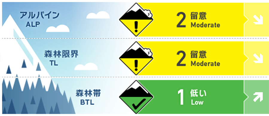
Hakuba
Alpine Low
Treeline Low
Below Treeline Fair Note rising temperatures and solar radiation during the day
信頼度:○ good □ Fair △ Low
Travel and Terrain Advice
Note the formation of wind slabs. Around ridges and on the sides of branch ridges are typical places. If the terrain there is shaped in such a way that it will not support a snowpack (convex, isolated, cliffs at the bottom, etc.), do not trust it, even if the snow surface is hard. As you move along, look for signs that the wind has blown, and look for simple terrain that is less affected by the wind. Also, along ridges and other wind-beaten areas, there are places where previous very hard ice layers are exposed. Beware of slips and falls. High temperatures are forecast for today. The danger of wet snow avalanches will increase in the afternoon at lower elevations. Remember to be vigilant above yourself. Have a good day.
Avalanche Problem
ウインドスラブ Wind slab


Be alert for wind slabs that have increased in hardness over time. When a windslab is triggered, it is normal for a fracture line to appear above you. In this case, it becomes very difficult to escape the avalanche. Around the main ridge, the winds were blowing very hard last night, averaging 30 m/s. That wind is using the terrain to go around and down to lower elevations. Even at lower elevations, be on the lookout for slab formation.
点発生湿雪雪崩 Wet Loose snow


Rating is as of morning. Watch out for avalanches of wet snow on steep slopes with strong effects of solar radiation and rising temperatures.
持続型スラブ Persistent slab


The danger of persistent slabs from ice sheets or Melt-Freeze crusts formed by the February 21 rainfall and faceted granular snow that formed on top of them remains highly uncertain.
概要
Avalanche
No new avalanche reports were received yesterday (15th).
Snowpack
Snow at lower elevations is in a spring cycle, with high temperatures and solar radiation promoting sintering, followed by melt-Freeze. On the other hand, at higher elevations, a fierce northwest to west wind blew yesterday afternoon, moving the snow violently. In the afternoon, the lifts at the top of the ski area were also closed.
Weather
The Japan Meteorological Agency is forecasting northerly winds and clear skies with a daytime high of 13 °C for northern Nagano Prefecture. At 703 m elevation in Hakuba, Japan, the temperature is 3.7 °C (as of 5:00 a.m.), and no new snow has fallen in the past 12 hours.
