Avalanche Bulletin
更新日時: 2021/11/28 07:07
Tateyama
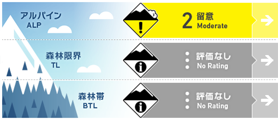
Alpine Low 昨夜まで荒天が続いていたため情報が少ない
Treeline
Below Treeline
信頼度:○ good □ Fair △ Low

Travel and Terrain Advice
Note the presence of new wind slabs on the steep slopes just below the ridge and support ridge. Also, be aware of the triggering of storm slabs from places of thin snow cover, such as wind-prone support ridges. The weak layer of this storm slab is deeply buried, so it is likely that it will increase in scale when induced. Pay attention to the possibility of avalanches from steep slopes overhead, even if you yourself are in a loose slope. Terrain traps such as rocks, deep ravines, and cliffs that increase damage when an avalanche occurs are exposed. Since stormy weather continues for a long time and there is little information, we recommend that you act while collecting information carefully.
Avalanche Problem
ストームスラブ Storm slab


積雪の薄い場所からの誘発に注意
ウインドスラブ Wind slab


稜線、支尾根直下の急斜面での誘発に注意
概要
Avalanche
Yesterday (27th), a human-induced plane avalanche size 1-1.5 was observed from the north to the northeast slope at an altitude of 1430m. In addition, there were reports of observing after an avalanche of size 2 or larger, thought to have occurred in the midst of stormy weather in Raidorizawa, but details are unknown.
Snowpack
There was about 40 cm of new snowfall from last night. Snowfall due to stormy weather lasting from 22nd has been on top of the old snow of 200cm or more, and sintering is progressing. Strong temperature gradients and recrystallization have been observed at the interface between this snow cover and the crust formed by rainfall, and attention should be paid to the degradation of coupling. Also, attention should be paid to the combination of the recrystallized former snow on the northern slopes of the high elevation zone unaffected by rainfall and the snow cover of the current stormy weather.
Weather
The current temperature at 6:30 in Murodo is -12.4 degrees Celsius. The Japan Meteorological Agency predicts that it will gradually be covered by high atmospheric pressure, but will initially be affected by cold and humid air, so it will be sunny from cloudy afternoon and rain until dawn.

