
雪崩情報
更新日時: 2021/12/04 07:00
ニセコ・羊蹄・余市・尻別
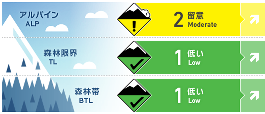
アルパイン Fair
森林限界 Good
森林帯 Good
信頼度:○ good □ Fair △ Low
行動と地形の助言
Snowfall amounts vary greatly across the zone and elevations bands. Use extra caution of new snow exceeds 30cms. Early season hazards exist at all elevations so travel with caution. The Niseko, Yoichi, Yotei, Shiribetsu avalanche bulletin will be available 3 times a week for the 2021-22 winter. Updates will be published at 7am on Tuesday, Thursday and Saturday throughout the season
留意すべき雪崩
点発生湿雪雪崩 Wet Loose snow


Warm, sunny weather on Monday will increase the possibility of loose wet avalanches on solar aspects at the end of the forecasted period.
ストームスラブ Storm slab


10-20cms of new snow arrived on Friday night with more expected to fall through the day on Saturday. Be wary of storm slab formation particularly as temperatures rise on Sunday.
ウインドスラブ Wind slab


Expect complex loading patterns from the strong Southerly flow on Friday which has now shifted to the NW, A Southerly flow will resume by Sunday afternoon.
概要
雪崩
Loose wet avalanches up to size 2 were observed in the Niseko region following the Dec. 1st rain event
積雪
2 rain events over the past week have caused significant settlement of the snowpack. Friday night brought 10-20cms of new snow to some parts of the zone and the bond of this new snow should be monitored. Lower elevations do not currently have enough snow for avalanches to occur.
天候
Saturday will be cool with snowfall expected to increase in the late afternoon before tapering off on Sunday morning leading to an overcast day. Skies will begin clearing Sunday afternoon leading to warm, sunny conditions on Monday. Wind will be light to moderate throughout the forecast period but shift from the NW on Saturday to a Southerly flow by Sunday afternoon.


