
Avalanche Bulletin
更新日時: 2021/12/07 07:00
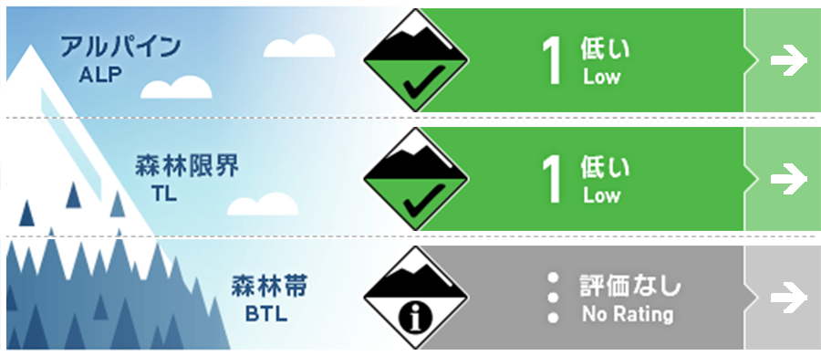
Niseko Yotei Yoichi Shiribeshi
Alpine Fair アルパインでは局所にウインドスラブ。Pockets of windslab can be found in the alpine.
Treeline Good 日射面で濡れた雪による点発生雪崩の可能性。Loose wet slides may occur on steep canyon walls exposed to solar radiation.
Below Treeline Good 標高が低いところでは十分な積雪がまだありません。There is not enough snow at low elevations for slab avalanches to occur.
信頼度:○ good □ Fair △ Low
Travel and Terrain Advice
The warm weather continues and the snow cover is decreasing. This makes it difficult to behave in the backcountry. Danger factors to be aware of at the beginning of the season, such as dense bushes and bamboo grass, interfere with the usual migration routes in winter. There is also the influence of vegetation, and caution should be exercised where the terrain is more open. The warm weather is causing the snowpack to continue shrinking. This is making backcountry travel increasingly difficult with thick bushes, sassa and Other early season hazards obstructing most winter travel routes. Be wary that the vegetation may push you to travel in avalanche paths where the terrain is MORE OPEN.
Avalanche Problem
点発生湿雪雪崩 Wet Loose snow


濡れた雪による雪崩が気温がとても髙い時間帯で発生の可能性が上がります。Loose wet slides will be most likely in the warmest parts of the day as the snowpack loses its cohesion.
ウインドスラブ Wind slab


概要
Avalanche
No new avalanches have been observed in the last 48 hours. No avalanche observations have been reported in the past 48 hours.
Snowpack
10 to 20 cm of fresh snow rests on a firmly frozen base. The total snow depth is about 30-80 cm depending on the altitude. Several wind slabs have been observed in the forest zone, but they are well coupled with the former snow surface, and the stable weather expected for the next few days seems to allow it to continue. 10-20cms of new snow sits on a well consolidated, re-frozen base. The total snowpack depth varies from 30-80cms depending on elevation. Some wind slab has been observed at treeline, however it is bonding well to the old snow surface and these bonds will continue to improve with the stable weather expected over the The next few days.
Weather
Due to the approach of the mobile high pressure, it is forecast that it will be generally sunny until Friday, and the temperature will be low. During this period, weak northerly winds will blow, and precipitation will be low. A high pressure system is moving into the region bringing mostly clear skies and mild Temperatures through until Friday. Throughout this period, the region will see a light Northerly flow with minimal precipitation.


