
Avalanche Bulletin
更新日時: 2021/12/15 21:20
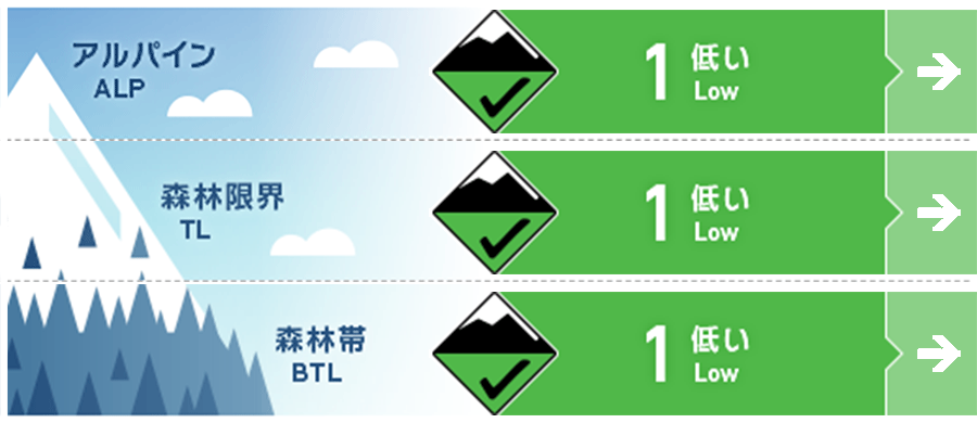
Niseko Yotei Yoichi Shiribeshi
Alpine Fair アルパインエリアの地形局所にウインドスラブがあります。Small pockets of wind slab are present in the alpine
Treeline Good ウインドスラブへの警戒は森林限界でより重要です。アルパインエリアよりも風が弱まり、私たちにとって危険なスラブが形成されやすいからです。The wind slab problem is more significant at treeline where slopes have been protected from strong alpine winds.
Below Treeline Good シーズン初めの危険要素に警戒してください。Beware of early season hazards
信頼度:○ good □ Fair △ Low
Travel and Terrain Advice
Be vigilant of the dangers at the beginning of the season Not enough buried bushes, rocks, tree roots, unburied swamp, etc. There will be severe weather conditions starting on Friday afternoon, so please plan ahead of time. Don't forget that avalanche information has a wide range of announcements, not just because the avalanche risk is low at present. It is important to check the situation in the field and adjust the action plan accordingly. Early season hazards continue to be the main concern with exposed bushes, rocks, roots and Open creeks making travel difficult. A significant storm will arrive on Friday so plan ahead to avoid high winds and poor visibility later that day. Remember that low hazard does not me no hazard and the bulletin covers a wide area. Monitor local conditions and adjust your plan accordingly.
Avalanche Problem
ウインドスラブ Wind slab


ウインドスラブは稜線直下の北や東に向いた斜面に形成しています。しかし、旧雪の結合状態は悪くなく、滑走者の刺激には鈍い状態です。Windslab has formed just below ridge crest on North and East aspects however it is bonding well to the old snow surface making it stubborn to skier triggers.
概要
Avalanche
No new avalanches have been reported for the past 48 hours. No new avalanches have been reported in the last 48 hours
Snowpack
Due to the high temperatures, snow in stormy weather settling quickly and binds well to the old snow. The lower layer of snow cover is well tightened. The depth of snow cover is diverse, about 120 cm on the northern slope, but about 30 to 80 cm in the other directions. Warm temperatures have caused rapid settlement of the storm, snow and it is bonding well to The old snow surface. The lower pack is well consolidated. Snow depth varies greatly depending on aspect with North slopes approaching 120cm depth while other aspects are at 30-80cms.
Weather
Today (Thursday), as the low pressure approaches from the south-southwest, the forecast says that the weather will continue to be mild. And since the next low pressure approaches Friday afternoon, heavy snow is forecast from the night. Thursday will bring continued mild temperatures and a mix of sun and cloud as a low Pressure system approaches from the SW. The next storm system will arrive mid-day Friday bringing heavier snowfall Friday night.


