
雪崩情報
更新日時: 2021/12/18 07:00
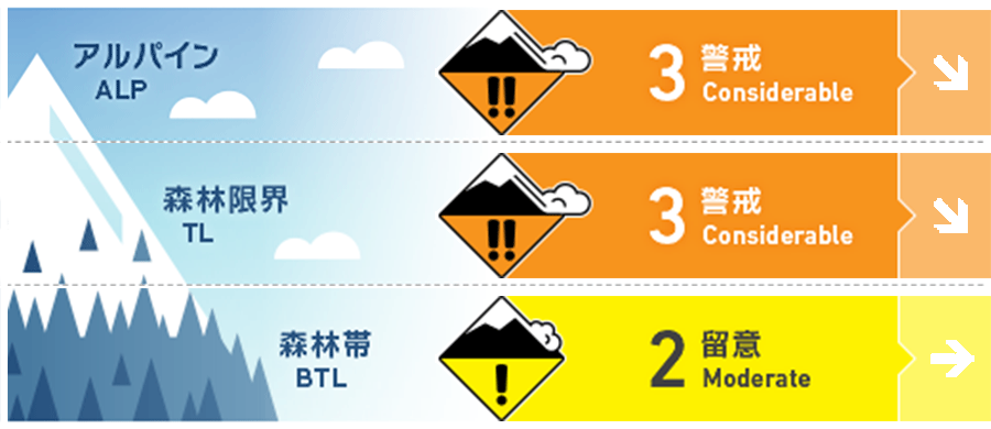
ニセコ・羊蹄・余市・尻別
アルパイン Fair 強風を伴う大雪のため、東から南東の斜面には大きな負荷が掛かっています。Heavy snow and moderate to strong winds have caused heavy loading on East and SE aspects.
森林限界 Fair 強風を伴う大雪のため、東から南東の斜面には大きな負荷が掛かっています。Heavy snow and moderate to strong winds have caused heavy loading on East and SE aspects.
森林帯 Fair 強風から守らえた場所にはソフトスラブの形成がありえます。Soft slab may be forming on slopes protected from the wind.
信頼度:○ good □ Fair △ Low
行動と地形の助言
新雪と旧雪の結合力が上がるまで、風下側の大きな斜面は避けてください。積雪の下に隠れているシーズン初めによくある危険要素に注意しつつ、地形の罠を合わせ持つ急斜面では、点発生雪崩の危険を考えた行動をお願いします。Avoid heavily loaded leeward slopes until the storm snow has had time to bond to the old snow surface. Beware of early season hazards lurking just below the snow surface and use caution on steep slopes above terrain traps where the consequences of a small loose dry avalanche will increase.
留意すべき雪崩
点発生乾雪雪崩 Dry Loose snow


急斜面では滑走者の刺激で点発生雪崩がありうる状況です。地形の罠に特に警戒してください。Loose dry avalanches reactive to skier triggers can be expected on steep slopes. Use extra caution above terrain traps.
ストームスラブ Storm slab


風の影響が小さい標高の低いところでは、ソフトスラブの形成に気づいてください。乾いた低湿度の雪は、密度の高いスラブを形成しにくい面があります。Look for soft slab at lower elevations where less wind transport has occurred. Dry snow and low humidity will prevent large, cohesive slabs from forming.
ウインドスラブ Wind slab


風下斜面では多量の堆積となっています。稜線直下や風が弱まる場所にウインドスラブが形成していないか、注視してください。Leeward slopes will be heavily loaded. Look for windslab just below ridge crest and on protected features.
概要
雪崩
過去48時間で新しい雪崩は報告されていません。No new avalanches have been reported in the past 48 hours.
積雪
過去24時間で、麓では40 cm以上の降雪となっています。よって、標高の高いところでは、より多くの降雪量が考えられます。新雪と旧雪が十分に結合するには、低温でもあり、時間が必要です。旧雪は十分に締まっており、安定しています。Up to 40cms of new snow has fallen at valley elevations in the last 24 hours. Expect considerably more snow to have accumulated on leeward slopes at higher elevations. This new snow will need time to settle and bond with the old snow surface. The lower pack is well consolidated.
天候
朝、一時的に強度の強い降雪は弱まりますが、火曜の朝までは、断続的な降雪が予報されています。この週末は中程度の北西風と、-10℃前後の気温となるようです。また、月曜にほは弱い南風が入ることで、天気は穏やかになる予報が出ていますが、気温はマイナスが続くとのことです。Heavy snowfall will ease to a more moderate rate this morning but it will continue snowing steadily until Tuesday morning. Moderate NW winds will persist through the weekend with temperatures steady near -10C. A weak Southerly flow will push into the region Monday bringing milder weather but temperatures will remain below 0C at all elevations.


