
Avalanche Bulletin
更新日時: 2021/12/18 07:00
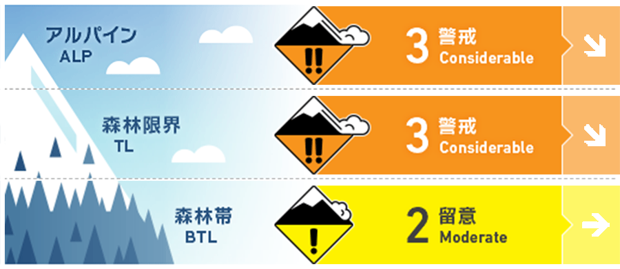
Niseko Yotei Yoichi Shiribeshi
Alpine Fair 強風を伴う大雪のため、東から南東の斜面には大きな負荷が掛かっています。Heavy snow and moderate to strong winds have caused heavy loading on East and SE aspects.
Treeline Fair 強風を伴う大雪のため、東から南東の斜面には大きな負荷が掛かっています。Heavy snow and moderate to strong winds have caused heavy loading on East and SE aspects.
Below Treeline Fair 強風から守らえた場所にはソフトスラブの形成がありえます。Soft slab may be forming on slopes protected from the wind.
信頼度:○ good □ Fair △ Low
Travel and Terrain Advice
Avoid large slopes on the leeward side until the bonding force between fresh and old snow increases. While paying attention to the hazards that are common at the beginning of the season hiding under the snow cover, please act in consideration of the danger of point occurrence avalanches on steep slopes with topographic traps. Avoid heavily loaded leeward slopes until the storm snow has had time to bond to the old Snow surface. Beware of early season hazards lurking just below the snow surface and use caution on steep slopes above terrain traps where the consequences of a small loose dry avalanche Will increase.
Avalanche Problem
点発生乾雪雪崩 Dry Loose snow


急斜面では滑走者の刺激で点発生雪崩がありうる状況です。地形の罠に特に警戒してください。Loose dry avalanches reactive to skier triggers can be expected on steep slopes. Use extra caution above terrain traps.
ストームスラブ Storm slab


風の影響が小さい標高の低いところでは、ソフトスラブの形成に気づいてください。乾いた低湿度の雪は、密度の高いスラブを形成しにくい面があります。Look for soft slab at lower elevations where less wind transport has occurred. Dry snow and low humidity will prevent large, cohesive slabs from forming.
ウインドスラブ Wind slab


風下斜面では多量の堆積となっています。稜線直下や風が弱まる場所にウインドスラブが形成していないか、注視してください。Leeward slopes will be heavily loaded. Look for windslab just below ridge crest and on protected features.
概要
Avalanche
No new avalanches have been reported in the last 48 hours. No new avalanches have been reported in the past 48 hours.
Snowpack
Over 40 cm of snowfall has occurred at the foot in the past 24 hours. Therefore, at higher elevations, more snowfall is conceivable. In order for fresh and old snow to combine well, it is also low temperature, and time is needed. The old snow is sufficiently tight and stable. Up to 40cms of new snow has fallen at valley elevations in the last 24 hours. Expect considerably more snow to have accumulated on leeward slopes at higher elevations. This new snow will need time to settle and bond with the old snow surface. The lower pack is well consolidated.
Weather
Strong snowfall will temporarily weaken in the morning, but intermittent snowfall is forecast until Tuesday morning. This weekend seems to have moderate northwesterly winds and temperatures around -10℃. Also, there is a forecast that the weather will be calm due to the weak south wind entering on Monday, but the temperature will continue to be negative. Heavy snowfall will ease to a more moderate rate this morning but it will continue snowing steadily until Tuesday morning. Moderate NW winds will persist through the weekend with steady temperatures near -10C. A weak Southerly Flow will push into the region Monday bringing milder weather but temperatures will remain below 0C at all elevations.


