
Avalanche Bulletin
更新日時: 2021/12/28 05:34
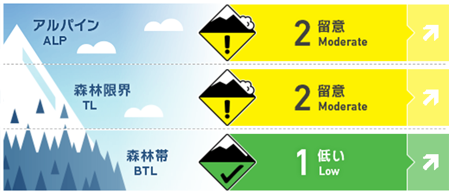
Niseko Yotei Yoichi Shiribeshi
Alpine Fair 明日に掛けての継続的な降雪は、積雪に負荷を掛け、面発生雪崩の可能性を押し上げます。Continued snowfall today and tomorrow will add load and increase the risk of slab avalanches.
Treeline Good 水曜は気温の上昇が予報されており、それによる雪崩の危険上昇を考える必要があります。Added load and rising temperatures will increase the avalanche risk on Wednesday.
Below Treeline Good まとまった降雪は昇温の影響を受けると板状の性格(スラブ化といいます)を持ち、人の刺激に反応しやすくなりますので、水曜日はそれを考慮してください。Beware of storm slabs consolidating and becoming reactive with rising temperatures Wednesday
信頼度:○ good □ Fair △ Low
Travel and Terrain Advice
Be very careful when moving in areas with more than 30 cm of new snow. The cornice is also getting bigger and softer as soon as it is formed, and it is unstable, so special care must be taken. Use extra caution if traveling in an area with 30cms or more of new snow. Cornices are increasing in size and should be approached with caution as they are soft and relatively unstable.
Avalanche Problem
ウインドスラブ Wind slab


西北西の風によって、稜線直下に形成しているウインドスラブに警戒してください。Look for windslab development just below ridge crest and lee to the WNW wind
ストームスラブ Storm slab


標高の低いところでは、水曜にかけての昇温の影響で、人的な刺激による雪崩の反応が出やすくなる可能性があります。Storm slabs may become increasingly reactive on Wednesday as temperatures rise particularly at lower elevations.
概要
Avalanche
No the new avalanche have been reported. No new avalanches have been reported.
Snowpack
A mass of about 1 meter of stormy snow rests on top of a thick, re-frozen rainfall crust. There was snowfall of about 5-10 cm in the Niseko area, but in other areas, there was almost no snowfall. Since it was sunny in Yoichi, which is north of the avalanche announcement area, and Mount Yotei and Mt. Shiribetsu in the east, it is necessary to consider the possibility of surface frost development. ~1 meter of consolidating storm snow sits on a 30-40cm thick re-frozen rain crust at the Bottom of the snow pack. The Niseko region received 5-10 cms of overnight snow while most of the rest of the region received little or no precip. Clear skies in the North (Yoichi) and East (Yotei & Shiribetsu) parts of the region may have caused surface hoar to have developed overnight.
Weather
It is forecast that continuous snowfall will continue into tomorrow. Currently, the northwest wind is strong, but it seems that tomorrow it will weaken slightly and the wind direction will change to the west. The low temperature will continue today, but tomorrow (Wednesday) it is forecast that the temperature will rise to near 0°C during the day at the foot of the mountain. Steady snowfall is expected to continue today and tomorrow. Winds will be moderate from the NW today then shifting to a light SW flow tomorrow. Cool temps continue through the day today but a rapid rise to near 0C in the valley is expected tomorrow (Wednesday).


