
Avalanche Bulletin
更新日時: 2022/01/06 07:00
Niseko Yotei Yoichi Shiribeshi
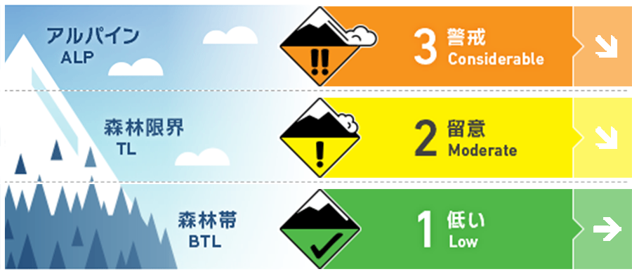
Alpine Fair 何日も継続した強い北風と大量の降雪で、風下側にはウインドスラブが形成しました。稜線直下は特徴的な地形には、局所的なスラブが存在しています。Multiple days of gale Northerly winds combined with high volumes of new snow available to transport will have resulted in wind slab formation on lee slopes. Pockets of slab will be found in specific areas below the ridgeline and terrain features.
Treeline Fair 直近の降雪と強風によって、風下側にスラブが形成しています。急斜面に滑りこむ前に、時間を掛けて状況を見極めてください。The latest new snow combined with strong to gale force winds will have created slab on the lee. Take the time to assess the conditions before stepping out onto steep angled terrain.
Below Treeline Fair 賢い地形選択を続け、急な沢地形や川が形成した崖状地形など、重大な結末をもたらす地形の罠を避けるようにしてください。Continue to make smart terrain choices and avoid clear terrain traps such as steeply angled gullies and riverbanks where the consequence will be higher.
信頼度:○ good □ Fair △ Low
Travel and Terrain Advice
Due to strong winds, the action has been limited to low elevations for the past few days. If you are aiming for higher elevations, you need to have a mindset beforehand. Look for a snow surface smoothly leveled by the wind below the leeward slopes and ridges. It's a place to be alarmed. Please be conservative in terrain with features that can easily lead to serious consequences. Gale winds over multiple days have kept terrain travel to lower elevations. An assessment mindset should be adopted if considering entering the alpine. Look for areas of smooth wind-pressed snow on lee slopes and below ridgelines which will indicate slab formation. Make conservative choices on higher consequence terrain.
Avalanche Problem
ストームスラブ Storm slab


これまでの荒天の不安定性の経過観察を続けています。全体として積雪の中間部は強度を上げてきていますが、積雪の薄い場所では強度が低く、荷重が掛かると雪崩が発生する可能性があります。We continue to monitor a previous mid-storm weakness from the end of last week. Over all the mid-pack has begun the gain strength although in thinner areas of snow cover this weakness may be exposed and produce results if over loaded.
ウインドスラブ Wind slab


北寄りの強風が数日続きましたが、今後、風向きが変わることでウインドスラブの形成場所が変わる可能性があります。After multiple days of gale winds from the Northerly quarter expect wind slabs to be found on lee slopes.
概要
Avalanche
No new avalanches have been observed reported. No new activity has been reported. If you have observed avalanche activity in the region please contact us.
Snowpack
The intensity of snow cover has been increasing after multiple stormy weather. There is concern about instability near the surface layer of snow cover, but overall the bonded state is in a good direction. The snowpack appears to be now gaining strength after multiple storm events. Near-surface instabilities are our greatest concern as the mid-pack is bonding well and shows little in the way of concern.
Weather
The first half of the week, which was followed by strong winds and heavy snowfall, ended, and the weather was settling down. As the high pressure passes over Hokkaido, it is forecast that fresh snow and wind will subside. However, this lull will soon end, and it is forecast to snowfall again this weekend. After strong to gale force winds and continuous snowfall early in the week we will move to A period of more settled weather. A high-pressure system will cross Hokkaido resulting in a drop in new snow totals and wind Speeds. This lull will be short-lived as we see increased snowfall at the end of the week.


