
Avalanche Bulletin
更新日時: 2022/01/13 07:00
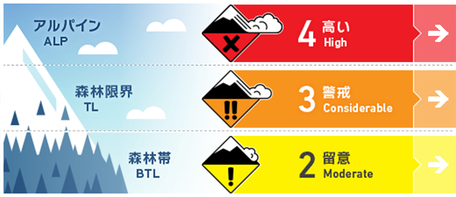
Niseko Yotei Yoichi Shiribeshi
Alpine Fair ストームスラブがいろいろな面で形成しており、小さい刺激にも反応する状態です。アルパインエリアの急斜面は、現時点では避けることが賢明です。Storm slabs will have formed on multiple aspects and are likely to be reactive to light loads. Steep angled terrain in the Alpine should be avoided at present.
Treeline Fair 直近の降雪は不安定であるため、ルートファインディングは複雑です。急斜面を避け、樹林内にある危険度の高い場所や、地形の罠に気をつけてください。Instability within the latest new snow will make route selection complex at present. Avoid steep terrain and be wary of high consequence areas and terrain traps in the tree line.
Below Treeline Good 新雪内にある脆弱性を探しつつ、重大な結末をもたらす地形に警戒を。Be wary of obvious features with high consequences as we look for weakness within this latest new snow.
信頼度:○ good □ Fair △ Low
Travel and Terrain Advice
Due to this stormy weather, setting a route for terrain movement is becoming more difficult, so please avoid terrain that will have serious consequences for the next 48 hours. So as not to miss clear signs of instability, such as whether there are traces of a the new avalanche, whether the cornice has collapsed, and whether there are shooting cracks. Lower elevations require special attention to steep slopes that trap terrain, such as the sides of river terraces. It will be wise to avoid consequential terrain for the next 48 hours as this latest storm will have created complex terrain travel. Take the time to properly look for obvious signs of instability such as recent avalanche activity, cornice failure, and cracking. At lower elevations be wary of micro features above terrain traps such as steeply angled River beds.
Avalanche Problem
ストームスラブ Storm slab


多量の降雪があり、強いあるいは暴風が吹いています。気温や風向風速の変化によって、新雪には不安定性が生じており、多様な方位、あるいは標高の高い場所では、小さい負荷(人の刺激程度)で反応する状態です。今回の荒天の期間で、雪崩サイクルがあったと考えるのが自然で、この新しいスラブが落ち着くまで、小さい負荷で反応すると考えてください。We have received a large amount of new snow across the region combined with gale to extreme winds. Changes in both temperature, wind direction, and wind speed during this latest storm have produced instabilities within the new snow that is expected to be reactive to light loads across multiple aspects and elevations. A natural cycle of avalanche activity is likely to have occurred during this storm period and the new slab formation will be reactive to light loads until it has time to settle.
概要
Avalanche
In the past few days, there have also been stormy weather, and there have been no reports of new avalanches. No new activity has been reported in the previous few days.
Snowpack
Before this stormy weather came, the snow cover had increased in strength as a whole, and it seemed that the strength was increasing firmly until the middle layer of the snow cover. Now, fresh snow, well over 50 cm, has fallen throughout the region, and the northwestern storm has also joined. Further observations are needed, but at multiple bearings and elevations, the formation of reactive slabs is strongly suspected. Previous to this latest weather event the overall snowpack had gained strength and appeared to be well bonded through the mid-pack. We have now received well in excess of 50cm of new snow across the region combined with Gale to Extreme North West winds. Although further observations need to occur we expect reactive slab formation across multiple aspects and elevations.
Weather
It is forecast that snowfall and strong winds will continue today. It is said that the stormy weather this time will calm down on the weekend. Continued snowfall and gale to extreme winds are expected to continue into Thursday. The storm system that has dominated the midweek will begin to move North by the weekend bringing more settled weather.


