
Avalanche Bulletin
更新日時: 2022/01/13 06:39
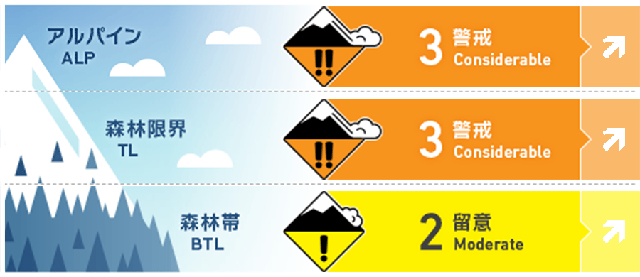
Kagura Tanigawa Hotaka
Alpine Low
Treeline Low
Below Treeline Fair
信頼度:○ good □ Fair △ Low
Travel and Terrain Advice
Note the presence of a new, uncoupled windslab, which is being formed on the steep slope by the strong winds that continued until last night. It is necessary to pay attention to triggering from places where the slope changes sharply. Since there is still little snow at low elevations, there are exposed “terrain traps” such as deep gullies, cliffs, rocks, and standing trees that increase damage even if the size of avalanches that occur is small. It is a forecast that the pressure arrangement of the winter type will increase. Please be aware of future weather changes and act accordingly.
Avalanche Problem
ウインドスラブ Wind slab


概要
Avalanche
There were no reports of observing a new avalanche yesterday (12th), but the observation was limited because visibility was poor and there were few people entering the mountain.
Snowpack
The elevation affected by the rainfall on the 11th is about 900 m or less. Snowfall that began on the 12th is about 30 cm, and it is blown away on slopes and ridges that are susceptible to wind, exposing old snow and crusts, forming wind slabs on leeward slopes and swamp terrain. The bush is thick in the lower elevation zone, and there are holes in the swamp.
Weather
As of 6:00, the temperature is -3.2℃ at AMeDAS Fujiwara. There has been 22 cm of snowfall in the past 24 hours, and it has gradually settling. There has been some snowfall in the vicinity. According to the Japan Meteorological Agency's announcement at 5:00 on the 13th, it is forecast that strong chills will flow into the sky from the afternoon and the winter-type atmospheric pressure arrangement will intensify, so it will be cloudy at the foot of the mountain and snow from the evening.