
Avalanche Bulletin
更新日時: 2022/02/10 07:00
Niseko Yotei Yoichi Shiribeshi
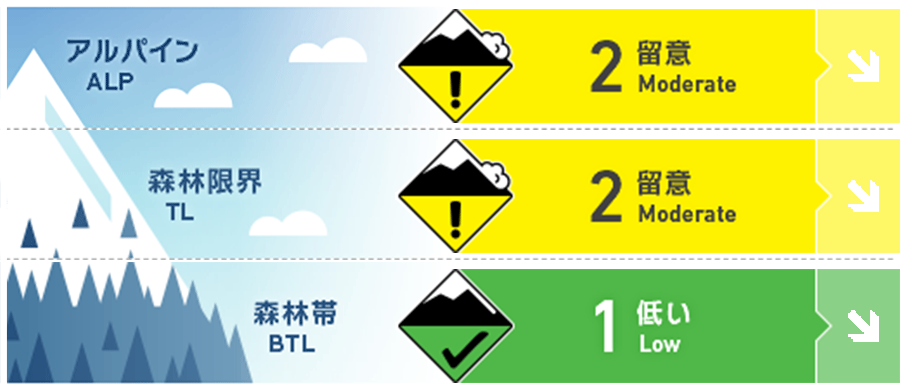
Alpine Good 急峻な地形で点発生乾雪雪崩がありえます。発表地区の北エリアでは、森林限界から標高の高いところで、ストームスラブの危険が継続しています。Loose-dry activity is expected in steep angled terrain. Lingering storm slabs may be found above treeline especially in the North of the range.
Treeline Good 数日間の降雪により、人的な刺激による点発生乾雪雪崩が急峻な地形ではありえます。After multiple days of new snow loose dry activity can be triggered in steep terrain.
Below Treeline Good 標高の低いところでは、グライドクラックが広範囲で観察されており、好天であってもそれは拡大し続けます。Glide cracks are widespread at lower elevations and may continue to grow under clear skies.
信頼度:○ good □ Fair △ Low
Travel and Terrain Advice
When the weekend overlaps with good weather after snowfall, the main routes of the backcountry become crowded. Pay attention to where the people around you are, and choose where to start or stop your run in a place where no other group is above you. Plan your day, use a general mode of travel, and think about returning safely to the trailhead. Sunny skies after a week of new snow combined with a public holiday weekend will produce a very busy backcountry on all major routes. Be mindful of where others are around you and choose safe stopping points on your ascent and descent to prevent people dropping in above you. Remember to have a plan for your day and follow your own safe travel techniques to make it back to the train head safely.
Avalanche Problem
ストームスラブ Storm slab


森林限界以上では、荒天の最中に生じるソフトスラブの不安定性が残っている可能性があります。これらのスラブは、特定の地形のみに存在し、人の刺激には鈍い反応を見せるでしょう。Mid-storm instabilities remain a possibility for failing and producing soft slab releases above the tree line. It is expected these slabs may be stubborn and be found in specific terrain.
点発生乾雪雪崩 Dry Loose snow


35°を超える急峻な地形であれば、広範囲に渡って、点発生乾雪雪崩が、人一人の刺激で起こりえます。結束性のない雪はが少量であっても、走路を流下する際に規模が拡大することがしばしばあります。Widespread loose dry activity can be triggered by light loads in steep angled terrain above 35 degrees. With plenty of low-volume new snow available, these loose dry avalanches can grow in size from a single point as they build mass in their path.
概要
Avalanche
Multiple point-generated dry snow avalanches have been observed and reported on steep terrain. These avalanches have been induced by ski cuts, etc., but have increased in magnitude to 1.5. In addition, glide cracks have occurred in a wide area at low elevations, and there have been reports of near-miss cuts related to it. Your observation information can be sent directly to the Ferecaster team by email. Multiple loose dry avalanches have been reported in the region in steep terrain. These slides were ski cut and are recorded up to size 1.5 which is enough volume to bury a person. At lower elevations, widespread glide cracks have been reported and near misses of people Skiing into these terrain traps have occurred just outside the ski area boundaries. You can contact the forecasting team with any observation at forecasters@nadare.jp
Snowpack
The middle and lower layers of snow cover are in a calm state. There was a reception for several days, and there was a lot of fresh snow. The instability of this most recent stormy weather generally tends to subside in a few days. The mid and lower pack remains strong and dormant at present. We have had multiple days of new snow with higher precipitation rates along the Sea of Japan coast. Instabilities have been recorded in the latest storm snow but these are expected to Stabilize over the coming days.
Weather
It will be sunny on Thursday, and it is forecast to last a few days. Since Hokkaido is covered by high pressure, the wind from the north is also weak. ・Clear skies are greeting us on Thursday morning and we are expecting sunny days with some broken clouds in the afternoon for the next couple of days. Wind speeds will remain low from the North as a large high pressures system reaches across Hokkaido.


