Avalanche Bulletin
更新日時: 2022/02/17 07:00
Niseko Yotei Yoichi Shiribeshi
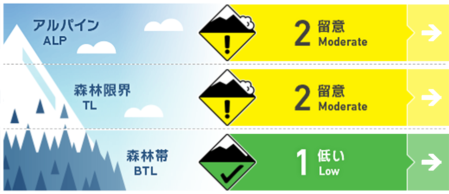
Alpine Good 標高の高いところでは、中程度から強い南東の風で、風下側にはスラブが形成しています。Moderate to strong South Easterly winds have transported snow onto lee slopes creating slabs at higher elevations.
Treeline Good 南東の風の風下側の地形局所に、風で移動した雪が堆積しています。Isolated small pockets of wind load may be found lee to the Southeast winds around specific terrain features.
Below Treeline Good 標高の低いところでは、グライドクラックが継続的に懸念事項となっています。Glide cracks remain a concern as they grow at lower elevations.
信頼度:○ good □ Fair △ Low

Travel and Terrain Advice
Look for a place where new snow has accumulated due to a different wind direction (southerly wind) than usual in the past few days. It may be a clue such as a snow cornice that has just formed. Then try to test the condition of the newly formed slab. As mentioned in each section of avalanche information, watch out for glide cracks at low elevations. With a slightly unusual wind direction over the last few days look for visual clues such as fresh cornice development for an indication of where the latest new snow has been Deposited and test the bond on any new slabs formed. As mentioned through out the forecast be wary of glide cracks at lower elevations.
Avalanche Problem
ウインドスラブ Wind slab


過去48時間、継続した普段とは異なる風により、ウインドスラブが地形局所に形成しています。この風で移動した北側の斜面の雪の下には、低密度で結合力の弱い雪があるため、不安定性を生じさせます。稜線付近では新しい風の影響の兆候を探してください。Small low volume pockets of wind slab may be found on lee slopes after a reverse wind pattern over the last 48 hours. This wind transported load will be deposited on low density loose dry snow on Northerly slopes creating a near-surface instability. Look for signs of fresh wind pressed snow around ridgelines.
概要
Avalanche
Multiple surface avalanches have been reported to the north of the region over the past few days. On February 15, a size 2 avalanche occurred across the northeast to the east slope. The elevation is around 900 m, and the depth of the break surface is about 35 cm. Also on the same day, an avalanche of size 1.5 occurred on the northern slope of Mt. Yoichi at an altitude of 1,050 m. The avalanche is about 15 m wide, but it flows down about 50 m. On the 16th, the avalanche that occurred on the north side of the 992 peak was 1.5 in size, 40 m wide at the break surface, 30 cm deep, and the downflow distance of about 80 m. Multiple slab avalanches have been reported over the last few days in the North of the range. On the 15th Feb a size 2 slab was triggered at 900m along a North East to East creek line The crown wall was 35cm and the bed surface. Also on the 15th a slab size 1.5 was triggered on the North face of Yoichi dake around 1050m the crown was 30-35cm fracture and the slide was 15m wide and ran for 50m. On the 16th a slab size 1.5 failed on some decomposing fragments within the previous snow On a Northerly aspect of 992 peak, the fracture was 30cm deep and the slide was 40m wide and ran for 80m.
Snowpack
After a snowfall of about 5 cm due to the southerly wind, the sunshine disappeared. Moderate to strong southerly winds are moving snow downwind. The middle and lower layers of snow cover are in a stable state, but at lower elevations, glide cracks continue to grow. We have received about 5cm of new snow from the South over the last few days and broken periods of sunshine. Moderate to strong Southerly winds have transported available snow onto lee slopes around ridgeline. The mid and lower packs remain stable however at lower elevations glide cracks continue to GROW.
Weather
In the afternoon of today (Thursday), the wind will change to northward, and then weak snowfall is forecast to begin. The wind speed remains weak, and there is no forecast of a consolidated snowfall after this. The winds will move back round to the North on Thursday afternoon indicating the start of light snowfall for the next few days. Wind speeds will remain low and we are not expecting much snow accumulation over the Coming days with the North of the range receiving the best numbers.


