
Avalanche Bulletin
更新日時: 2022/02/19 07:00
Niseko Yotei Yoichi Shiribeshi
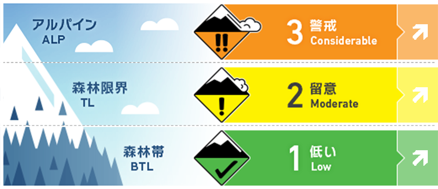
Alpine Fair 今後の降雪と風の程度によって、ストームスラブの形成があります。Storm slabs are expected to form in the coming days as wind speeds and new snow totals increase.
Treeline Fair 森林限界付近では、来週始めまでにスラブの形成がありえます。Slab will form by early next week in the tree line.
Below Treeline Fair 複数のグライドクラックの崩落がありました。Multiple glide crack releases have occurred at lower elevations
信頼度:○ good □ Fair △ Low
Travel and Terrain Advice
A careful approach is needed to determine what the stormy weather will be in these days. If there are strong winds and a lot of snowfall, it is better to avoid high altitude areas and look for suitable terrain at low elevations. A cautious approach is required in the coming days as we wait to see how the forecasted Storm will develop. If gale-force winds and higher snow totals occur staying out of the alpine and focusing on The lower angled terrain will be needed.
Avalanche Problem
ストームスラブ Storm slab


春のようなコンディションが終わり、週明けには新たな荒天が始まるため、雪崩コンディションも上昇するでしょう。森林限界やアルパインでは、降雪と北西の風によって、ストームスラブは形成されていきます。このような状況のときは、荒天の雪が落ち着くまで、標高の低い場所にとどまるのは賢明な判断といえます。After a brief period of spring like conditions, we are expecting the avalanche hazard to increase by early next week as a new storm system affects Hokkaido. Increased snowfall and gale North Westerly winds will build storm slabs in the tree line and alpine. It may be wise to stay on low angle terrain until the expected new snow has time to settle.
概要
Avalanche
Multiple spontaneous avalanches have been reported over the past few days. On the southeastern slope of Mt. Shiribetsu, a full-layer avalanche occurs that reaches the end of the avalanche road. Also, avalanches of size 2 wind slabs have been reported on the slopes facing north. Over the previous few days, multiple natural avalanches have been reported across the range. Glide cracks have released on Shiribetsu dake on the South Easterly aspects and have run full path. Wind slabs avalanches have also occurred in the Northerly half up to size 2.
Snowpack
The southerly winds from the middle of the week have deposited snow on the northern slopes, where the combination of fresh and old snow is weak. Considering the weather situation after this, it is possible that the instability of the slope will increase further as wind and snow intensify. Southerly winds from mid week have redistributed snow onto the Northerly half where the Bond between the new and old snow interface has been weak. As we receive new preceiptiation over the coming days from the North this will be falling on a previously wind stripped surface where the bond may be weak.
Weather
This weekend is forecast to be mild, with little snowfall and light winds. However, due to the effects of low pressure, strong northwestern winds and heavy snowfall are said to continue until the beginning of the week from Sunday evening. We expect calm conditions early in the weekend with little snowfall and low winds. However, an intense low-pressure system will begin to affect Hokkaido by late Sunday evening bringing gale force North Westerly winds and storm conditions throughout the early Part of next week.


