
Avalanche Bulletin
更新日時: 2022/02/20 04:41
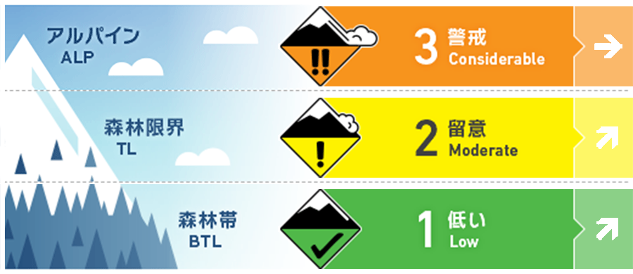
Kagura Tanigawa Hotaka
Alpine Low
Treeline Fair
Below Treeline Fair
信頼度:○ good □ Fair △ Low
Travel and Terrain Advice
Note the joining of the storm slabs on the steep slopes. Merging is unlikely to be progressing at high elevation bands. It is necessary to pay attention to triggering in places where the slope changes sharply. Be careful of “terrain traps” such as cliffs and deep rivers, which increase damage even if the scale of avalanches that occur is small. It is a forecast that the atmospheric pressure arrangement of winter type will be in the future Pay attention to changes in snowfall and wind effects.
Avalanche Problem
ストームスラブ Storm slab


概要
Avalanche
Yesterday, it was reported that multiple surface avalanches of size 1 and size 1.5-2 were observed on the northwestern slope at an altitude of 1500-1700m.
Snowpack
There were places with low density and poor coupling in the snowfall until yesterday, and surface avalanches were observed yesterday due to human stimuli and spontaneous occurrence. The layer with poor coupling is buried even deeper due to new snowfall since last night. It is expected that sintering of this layer is not progressing in the high elevation zone, so care must be taken. Bonding in the middle layer of snow cover is good.
Weather
The temperature at AMeDAS Fujiwara as of 4:00 a.m. Snowfall for the past 12 hours is 5 cm. Snowfall continues around the area. According to the Japan Meteorological Agency's announcement at 17:00 on the 19th, a low pressure develops, passes through the coast of the Kanto region, advances to the Kuril coast at night, and becomes a winter-type atmospheric pressure arrangement, so it is forecast to be cloudy in the northern part of Gunma prefecture and snow in the morning and evening.