
Avalanche Bulletin
更新日時: 2022/02/20 06:00
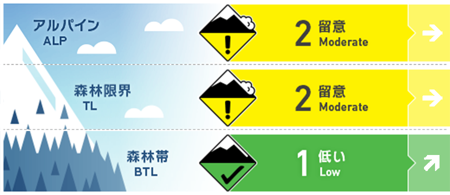
Myoko
Alpine Fair 今後の降雪に留意
Treeline Fair 今後の降雪に留意
Below Treeline Fair 今後の降雪に留意
信頼度:○ good □ Fair △ Low
Travel and Terrain Advice
Those who raise the elevation should pay attention to the formation of wind slabs. A strong westerly wind is blowing in the sky, so be sure to see where the wind wraps along the terrain and cross loading snow. If you see signs of the formation of new slabs on the snow surface, try to avoid convex or isolated terrain, which is an easy place to provoke. On the other hand, be wary of glide cracks at low elevations. It is often formed in places that cannot be seen from the top of the slope. The weather clearly tends to deteriorate, so make an action plan that takes that into account.
Avalanche Problem
ウインドスラブ Wind slab


概要
Avalanche
There was no observation report of a the new avalanche yesterday (19th).
Snowpack
Snow in stormy weather has settling sufficiently and is not responding to major stimuli in the below treeline. At very low elevations, the snow surface is wet. The snowfall until this morning is listed here, but the amount is small at the moment.
Weather
The Japan Meteorological Agency predicts the west wind, rear, and northwest winds, slightly stronger, snow or rain, and a maximum temperature of 4℃ (elevation 13 m) for the Joetsu region of Niigata prefecture. At Myoko Kanzan (altitude 350 m), the temperature was 0.6℃ (as of 5:00), and there was a snowfall of 4 cm in the past 12 hours. The Meteorological Agency has announced weather information on heavy snow at 5:56 on February 20, and is reporting the expected snowfall of 70 cm along the mountain in Joetsu for 24 hours from 6:00 on the 20th to 6:00 on the 21st.