
Avalanche Bulletin
更新日時: 2022/02/24 07:00
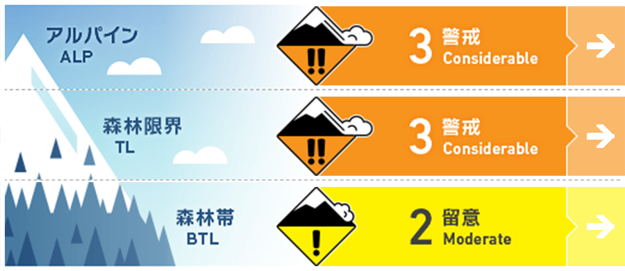
Niseko Yotei Yoichi Shiribeshi
Alpine Fair 北西の強風が風下に雪を運び、週の初めにスラブを形成させました。Gale force North Westelty winds have transported snow onto lee slopes creating slab earlier in the week.
Treeline Fair 北西の風によるウインドスラブが形成しています。Wind slabs have formed lee to the North West winds.
Below Treeline Fair 地形局所に小さい規模のスラブが形成している可能性があります。Low volume pockets of slab may be found in isolated terrain features.
信頼度:○ good □ Fair △ Low
Travel and Terrain Advice
Sufficient field observations have not been performed during storms and snowstorms. After heavy snowfall and strong winds, it is necessary to take time to check what conditions the snow cover is in. The biggest concern now is the combined state of the crust formed on the southerly slopes and the stormy snow that rests on it. When you are in a complex snow condition, it is recommended that you stay on a gentle slope. Little in the Way of Observations have been taken throughout the latest storm period. With so much new snow and wind in the early part of the week taking the time to Investigate what is occurring in the snowpack is a must. Our biggest concern is the bond between the latest new snow to a sun crust across the Southerly aspects. With a complex snowpack at present staying on lower angle terrain is advised.
Avalanche Problem
ウインドスラブ Wind slab


今週の前半、継続した降雪と強風により、標高の高い場所ではスラブが形成しました。ウインドスラブによる雪崩は、北西の風の風下側の特定の斜面に、あまり大きくない負荷が掛かるだけで発生する可能性があります。スラブが形成した場所を探す際、東側の斜面において、クロスローディングしている兆候を見つけてください。雪崩が発生した場合、人を埋めるに十分な雪の量が動きます。With constant snowfall and gale force winds earlier in the week slabs have formed at upper elevations. We expect avalanches can be triggered by light loads in specific areas lee to the North West winds. Look for signs of smooth wind-pressed snow across the Easterly half as an indicator of where slabs have formed. It is likely any avalanche that occurs will be large enough to bury a person.
概要
Avalanche
Due to limited action in mountainous areas, no new avalanches have been observed in the past few days. There have been reports of waffing sounds in places with loose slopes near forest limits. No new avalanche activity has been recorded in the past few days though travel into the backcountry has been limited. We have had reports of whumpfing on lower angle terrain in the treeline.
Snowpack
There was a snowfall this week accompanied by very strong northwesterly winds, the volume of which exceeded 100 cm. Before this stormy weather, melting and freezing crusts were formed on the southern slopes. Our biggest concern is that there are test results that suggest poor coupling between this old snow surface and this snowfall. Over 100cm of new snow has been recorded this week with Gale North West winds. Previous to the latest new snow Southerly aspects had a crust on the surface. This interface between the new and old snow is our greatest concern with test results Suggesting a poor bond.
Weather
The effects of the low pressure located in the Pacific Ocean still remain. The recent weak snowfall was accompanied by a rather weak northwesterly wind. It is forecast that the sun will peep through the clouds and the temperature will rise this weekend. We continue to feel the effects of a low pressure in the Pacific. Snow showers will occur throughout the later part of the week with moderate North Westerly winds. We are expecting periods of broken sunshine and warmer temperatures by the weekend.


