Avalanche Bulletin
更新日時: 2022/02/25 06:00
Myoko
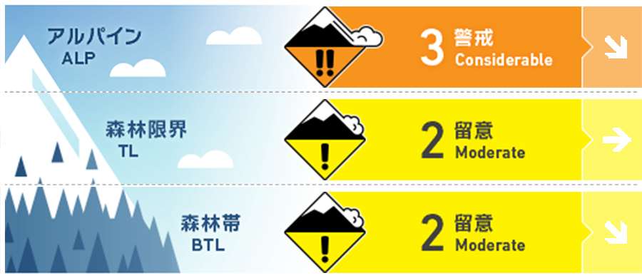
Alpine Low
Treeline Fair
Below Treeline Fair
信頼度:○ good □ Fair △ Low

Travel and Terrain Advice
The condition differs depending on the elevation and direction. If you are going to raise the elevation, pay attention to the windslab formed by the westerly winds. The wind wraps around along the terrain, so it is not simply an eastern slope. It is important to see where the snow is moving and where it is crossloading. By closely observing the condition of the snow surface, you can see the effects of winds that blew in the past Avoid unsupported terrain where snow cover is prone to instability, isolated or convex, and other places that are likely to be trigger points, and look for simple terrain with weak wind effects. Even if you feel that the snow cover is stable, adhere to the principle mode of behavior, such as stopping in a safe position or gliding one by one. It reduces accidents in the unlikely event of an accident. Have a safe day
Avalanche Problem
ストームスラブ Storm slab


ウインドスラブ Wind slab


概要
Avalanche
Yesterday (24th), due to the recovery of the weather, visibility was opened, and avalanches of size 3.5 (2 m in fracture surface thickness, 800 m in width) that seem to have occurred during stormy weather, and multiple size 2-2.5 avalanches were observed . In addition, avalanches of size 2-2.5 have also been reported in the safety management of the ski area.
Snowpack
It has been observed that heavy snowfall is steadily in the direction of settling and stabilization at low elevations. On the slopes that were exposed to yesterday's insolation, thin crusts are also formed. On the other hand, when the elevation is raised, a medium to strong wind toward the west is continuously blowing, and the formation of wind slabs has also been confirmed.
Weather
The Japan Meteorological Agency predicts snow or rain until afternoon, and a maximum temperature of 7℃ (elevation 13 m) for the Joetsu region of Niigata prefecture depending on the wind, cloudy weather, and place in the west. At Myoko Kanzan (altitude 350 m), the temperature is -4.0℃ (as of 5:00), and there is no new snowfall in the past 12 hours.

