
Avalanche Bulletin
更新日時: 2022/02/26 07:00
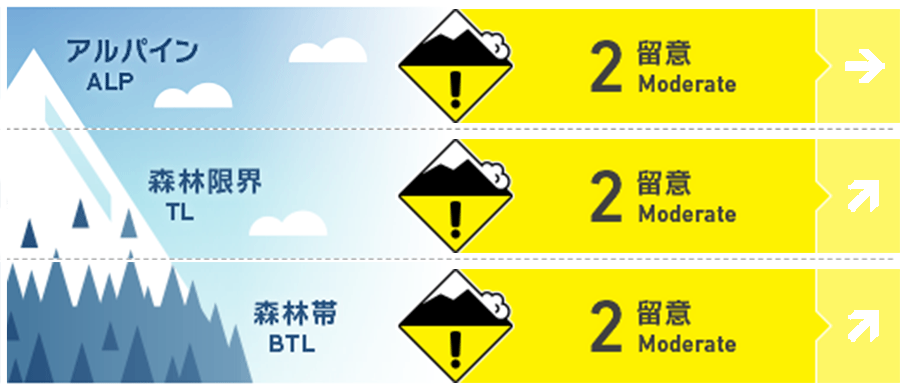
Niseko Yotei Yoichi Shiribeshi
Alpine Good 局所のスラブが、北西風の風下側に残っています。Pockets of slab remain and higher elevations lee to the NW winds.
Treeline Fair 本日(土曜)の昇温が南斜面で濡れた点発生雪崩の原因となるでしょう。Warm temperatures on Saturday may produce wet loose activity in the South.
Below Treeline Fair 凍結高度は上昇しています。日中、グライドクラックの入った斜面の下に入らないでください。With a rising freezing level avoid spending any time below glide cracks in the middle part of the day.
信頼度:○ good □ Fair △ Low
Travel and Terrain Advice
Visibility is good and the temperature rises moderately, making it a good day for the backcountry. Look for signs on the leeward slopes that the wind that blew so far caused the slab to redistribute the snow cover and form it. The effects of rising temperatures and solar radiation are strong today, so do not approach slopes with glide cracks. With good visibility and warm temperatures now is a great time to head into the backcountry. Look for any signs of where last week's wind events have redistributed our latest snowfall and look for slab formation on lee slopes. With warmer temperatures and sunshine on Saturday avoid spending any time below glide cracks in the middle of the day.
Avalanche Problem
点発生湿雪雪崩 Wet Loose snow


本日、予報されている昇温と日射の影響によって、標高が低い、南に面した斜面では、濡れた雪による点発生雪崩が起こりえます。スノーボールは雪面の雪が不安定となっている兆候です。濡れた雪による点発生雪崩が重いため、雪の量が増えると重大な結末を招きます。With a rising freezing level and sunshine expected on Saturday wet loose activity may occur at lower elevations across Southerly aspects. Any roller balling (snowballs rolling down a slope) is an indication that the surface snow is becoming unstable. Wet loose avalanches can build in mass and are very heavy producing higher consequences.
ウインドスラブ Wind slab


地形局所に孤立して存在するウインドスラブが、標高の高い場所では残っています。尾根の風下側にある風の兆候を探してください。このスラブはとても急な場所などでは、小さい荷重で反応しえます。Pockets of Isolated winds slab remain in specific areas at higher elevations. Look for signs of wind-pressed snow below ridgeline. These slabs be reactive to light loads in steep exposed terrain.
概要
Avalanche
No the new avalanche have been reported. No new avalanche activity has been reported.
Snowpack
Snow in stormy weather is showing calm and strength is also increasing. The warming up this weekend should boost this trend. Wind slabs formed locally due to northwestern winds may hide crusts beneath them. The snowpack has begun to settle from the previous storm events and gain strength. Warmer temperatures over the weekend will continue to promote this trend. Lee to the NW winds pockets of slab at higher elevation overlie a buried crust which can Be felt in exposed areas.
Weather
Warming with southerly winds is predicted to raise the freezing altitude to 700 m. It is forecast that the next few days will be sunny or cloudy, and there will be no heavy snowfall. A Southerly Flow on Saturday will bring warmer temperatures to the region with the Freezing level rising to 700m. We are expecting broken periods of sunshine and little in the way of new snowfall for the Coming days.


