
Avalanche Bulletin
更新日時: 2022/03/05 07:00
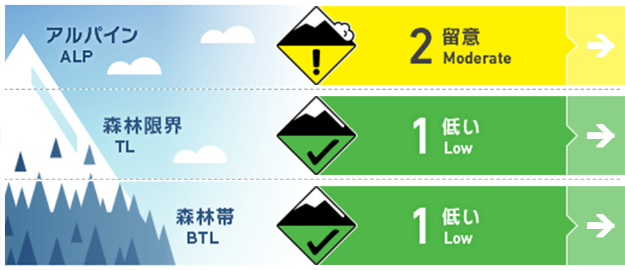
Niseko Yotei Yoichi Shiribeshi
Alpine Good 孤立して形成したウインドスラブが稜線の風下側にあります。Isolated pockets of wind slab can be found in exposed areas below ridgeline.
Treeline Good 小さいスラブが北西に面した急斜面に形成している可能性があります。Low volume slab may be found lee to the North West in steep terrain.
Below Treeline Good 標高の低い場所は、春のコンディションです。グライドクラックが懸念事項です。Spring conditions can be found at lower elevations with glide cracks remaining a concern.
信頼度:○ good □ Fair △ Low
Travel and Terrain Advice
The temperature rise during the day is large, and the snow cover at low elevations is wet, heavy, and it is also a stop snow. Since glide cracks are expanding, the risk of collapse increases on days when the temperature rises significantly. Please also be aware of falling snow from trees on weekends when the wind intensifies. The snow is so heavy that it will be a big accident if it hits. As we are now experiencing warm conditions during the day, the snowpack at lower elevations is becoming heavy and sticky, glide cracks have continued to grow and are a concern to Fully release on any warm day. With increased winds over the weekend watch for chunks of frozen snow that have fallen from trees and can cause accident if you come into contact with them.
Avalanche Problem
ウインドスラブ Wind slab


地形内に孤立して形成しているウインドスラブが、風下斜面に形成している可能性があります。このスラブは人の刺激に対しては鈍く、誘発しづらいでしょう。この週末は荒れた鉄器となり、15 cm以上の降雪があった場合、南側の斜面には警戒すべきスラブが形成されると考える必要があります。Isolated pockets of winds slab may be found in exposed terrain at higher elevations below ridgeline lee to the North West winds. Currently, it is expected that this slab will be hard to trigger. Gale-force winds are forecasted over the weekend and new slab may build across Southerly slopes if we also receive new snow accumulation greater than 15cm.
概要
Avalanche
No new avalanches have been observed reported in the past few days. No new avalanche activity has been reported over the last few days.
Snowpack
The warmer temperatures of the past few days have prompted changes in the snow cover and increased its intensity. The snow from the stormy weather that existed until then forms a well-sintered layer with a thickness of about 40-60 cm in the middle layer of snow cover. In places with low elevations, it is a spring thaw freeze cycle. Warmer temperatures throughout the last several days have helped to consolidate the snowpack and allow it to gain strength. The latest new snow and wind events appear to have now settled with 40 to 60 cm of well- Bonded snow overlying no reactive instabilities in the mid-pack. At lower elevations, we are now starting to see spring melt-freeze conditions beginning.
Weather
The low pressure passed over the weekend, and strong northwesterly winds due to the winter-type atmospheric pressure arrangement are forecast. In addition, although the duration is short, it is also forecast to have a consolidated snowfall. A low-pressure system will pass over the region during the weekend bringing wind Speed rising to gale conditions from the North West. We can also expect periods of snowfall that will be short-lived.


