
Avalanche Bulletin
更新日時: 2022/03/06 05:30
Hakuba
Alpine Fair
Treeline Fair
Below Treeline Good
信頼度:○ good □ Fair △ Low
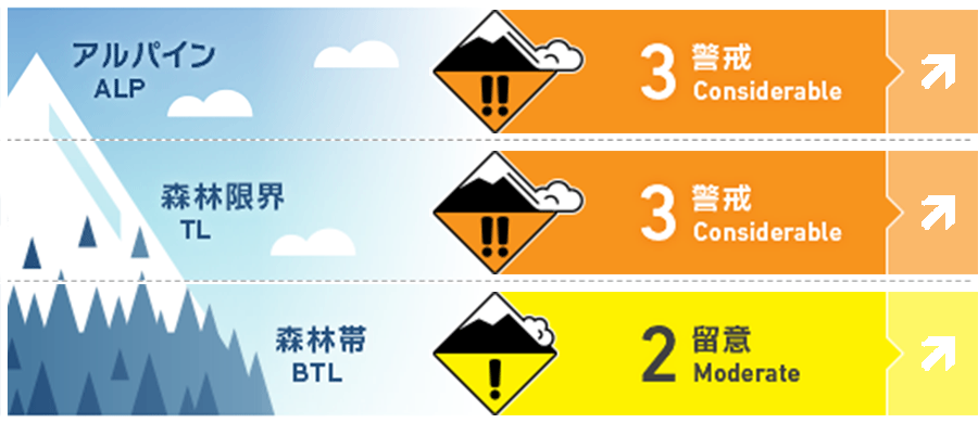
Travel and Terrain Advice
This is a dangerous avalanche condition. The snowfall since yesterday is strongly affected by the wind and rests on the old snow surface. Avalanches can occur from weak points in fresh snow or from the boundary between fresh snow and old snow. The state of the old snow surface varies considerably depending on the elevation band and bearing, and the degree of coupling remains highly uncertain. It is necessary to check the status on the assumption that the overall situation is bad. Even if you are in a forest zone, pay attention to the outbreaks and runways within it. Think about whether there are large outbreaks above you. If you are inexperienced, we recommend that you enjoy it in the fresh snow area of the ski resort. Snowfall is forecast to intensify in the future, so make an action plan that takes that into account.
Avalanche Problem
ストームスラブ Storm slab















概要
Avalanche
No the new avalanche were reported yesterday (5th).
Snowpack
Yesterday (5th), a very warm southwest wind entered, and the temperature rose sharply to 10° C during the day at the foot of the mountain. As a result, the snow surface layer in the forest zone became sufficiently wet. At high elevations, snowfall began yesterday afternoon, and it has been 20-30 cm of snowfall by this morning in the upper part of the below treeline. In the vicinity of the main ridge, there is a storm on the west side, and the snowfall until this morning to the lower elevation has been affected by the wind.
Weather
The Meteorological Agency forecasts northern Nagano prefecture with northern wind, cloudy, occasional snow, and a maximum temperature of 3℃ (elevation 418m). At the foot of Mt. Hakuba (elevation 703m), we have observed snowfall of 10 cm in the past 12 hours with a temperature of -3.6℃ (as of 5:00 p.m.). The Nagano District Meteorological Observatory is calling attention to heavy snowfall in the mountainside area starting before today's morning. The quantitative forecast for 50 cm has come out in 24 hours until tomorrow (7th) morning.


