
Avalanche Bulletin
更新日時: 2022/03/06 06:00
Myoko
Alpine Low
Treeline Fair
Below Treeline Fair
信頼度:○ good □ Fair △ Low
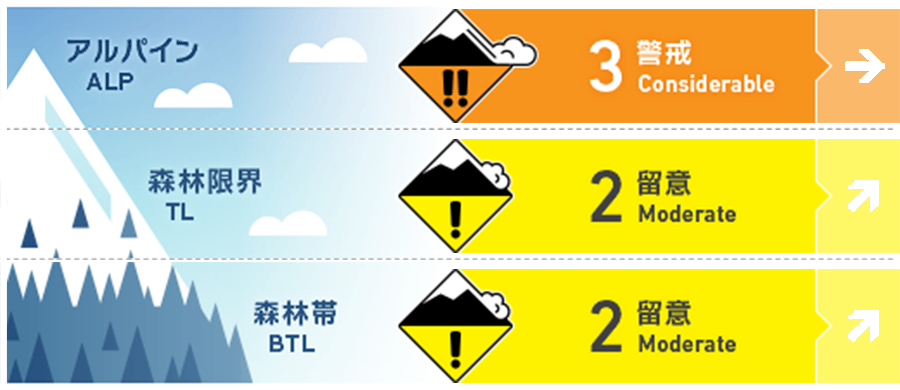
Travel and Terrain Advice
This is a dangerous avalanche condition. The snowfall since yesterday is strongly affected by the wind and rests on the old snow surface. Avalanches can occur from weak points in fresh snow or from the boundary between fresh snow and old snow. The state of the old snow surface varies considerably depending on the elevation band and bearing, and the degree of coupling remains highly uncertain. It is necessary to check the status on the assumption that the overall situation is bad. Even if you are in a forest zone, pay attention to the outbreaks and runways within it. Think about whether there are large outbreaks above you. If you are inexperienced, we recommend that you enjoy it in the fresh snow area of the ski resort. Have a safe day
Avalanche Problem
ストームスラブ Storm slab








概要
Avalanche
Yesterday (5th), at a very low elevation, multiple point-generated wet snow avalanches of size 1 have been observed.
Snowpack
Yesterday (5th), a very warm southern wind entered, and it became cheerful in spring at the foot of the mountain. Along with this, the snow surface layer of the forest zone became sufficiently wet, and the snow that lost strength moved as a point generation avalanche. At high elevations, snowfall began yesterday afternoon, and it has become a consolidated snowfall in the below treeline. In the sky, a storm of westerly winds is blowing, and the snowfall until this morning has been affected by the wind to the lower elevations.
Weather
The Japan Meteorological Agency predicts strong winds, snow or rain in the west, and a maximum temperature of 5 degrees Celsius (elevation 13 m) for the Joetsu district of Niigata prefecture. The temperature is -8℃ (as of 5:00) at Myoko Sasagamine (elevation 1,310m). It has been snowfall of 20-30 cm in the past 12 hours at an altitude of 1,000 m.

