
Avalanche Bulletin
更新日時: 2022/03/08 07:00
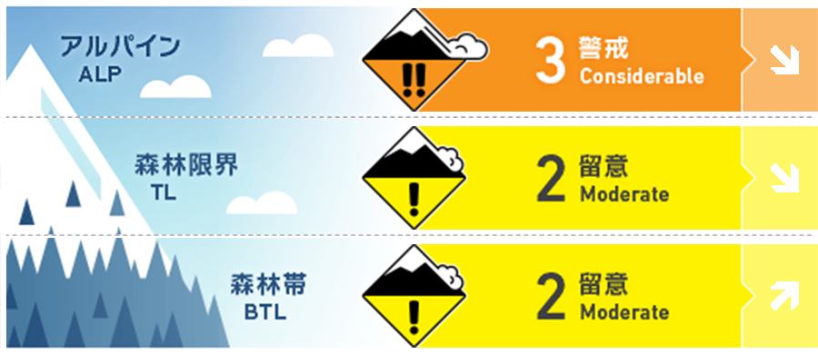
Niseko Yotei Yoichi Shiribeshi
Alpine Good アルパインの風下斜面には硬いウインドスラブが形成しています。Stiff wind slabs can be found on lee slopes in the Alpine.
Treeline Good 地形局所に孤立した状態で局所のスラブが形成しています。Pockets of slab can be found in isolated terrain features.
Below Treeline Good 晴天は今後数日、凍結高度を押し上げます。よって、それに伴って標高の低い場所では濡れた雪の点発生雪崩に注意する必要があります。Clear skies and rising freezing levels over the next few days will increase the possibility of loose wet avalanches at lower elevations.
信頼度:○ good □ Fair △ Low
Travel and Terrain Advice
In the Alpine area, a careful approach is required until the wind slab formed by the most recent wind settles down. Since this slab is hard, it is difficult to trigger, but if triggered, it can increase in scale. The cornice that has just formed is brittle, and when it collapses, it often pulls snow on the ridge more than expected. Also, future temperature increases the possibility of avalanches due to wet snow. When crossing a sunny slope, think about what kind of terrain traps lie beneath it. A cautious approach should be adopted to the Alpine in the coming days as we wait for the SLABS formed during the latest wind event to settle. The slabs are stubborn and may be hard to trigger but if released the consequence may be high. Fresh cornice formation will be brittle and cornice could break further than expected back on Ridgeline. Glide cracks may be covered by wind-blown snow and will be hard to see from above. As the Temp's rise in the coming day so will the wet loose activity so be mindful of what Terrain traps are below you as you cross any sunny slope.
Avalanche Problem
点発生湿雪雪崩 Wet Loose snow


明日(水曜日)は更に気温が上昇し、好天のため、その影響を強く受ける急斜面では、濡れた雪の不安定性に注意が必要となります。雪玉が雪面を転がるスノーボールは、雪面の雪の結合力が低下しているサインです。これは別の斜面を選んだほうがよい、という指標になるでしょう。Wednesday is forecasted for rising freezing levels and clear skies resulting in the possibility of loose wet activity in steep terrain. Roller balling (snowballs naturally falling down a slope) is a good indication that the snow surface is losing cohesion and becoming weak. This should be a sign for you to move on to a different aspect.
ウインドスラブ Wind slab


先週末からの北寄りの強風の影響で、標高の高い場所では、風下側に硬いウインドスラブが形成しています。この場所は刺激に対して強固ですが、特定の場所で誘発されると、人を埋めるほどの規模となりえます。稜線付近に形成した雪庇を観察し、風が吹いた痕跡を探してください。急斜面において、風でならされたような滑らかな雪面があった場合、そこは避けるようにしてください。Gale force winds from the North at the end of last week have produced stiff wind slabs on lee slopes at higher elevations. These slabs are expected to be stubborn but if triggered in specific areas they will be enough to bury a person. Look for signs of fresh cornice formation along ridgeline to indicate where the wind has been blowing and avoid areas where smooth wind-pressed snow is on the surface in steep terrain.
概要
Avalanche
No brand new avalanches have been reported in the avalanche information release area. However, in the northern part of the region, waffing sounds and shooting cracks have been observed in slabs that have just formed. No new avalanches have been reported in the forecast region although whooping and shooting cracks have been recorded in the North within the latest wind slab formations.
Snowpack
The expression of the snow cover changed drastically due to the recent strong winds. In many places, snow on the windward side has been stripped, and hard slabs form on the leeward side. Also, hard snow surfaces are exposed in Alpine. This stiff wind slab rests on top of low density fresh snow, so it has an inverted structure. Some fresh snow shook last night (Monday night), so it may be hiding this hard slab. The Snowpack has been transformed during the latest wind event. The Windward side in many areas has been stripped leaving a firm surface at high elevations whilst stiff stubborn winds slabs have formed on the lee. Observations suggest these slabs overlie lower density new snow creating a density inversion. Overnight on Monday, we have received a further 5cm of new snow which may mask where these slabs are located.
Weather
After the temporary snowfall until this morning (Tuesday morning), it is forecast that the weather will be good for the next few days and the wind will be weak. The freezing altitude will also rise to about 700 m, and it will be cheerful in spring. After a brief period of snowfall early on Tuesday the clouds should part bringing a few Days of Clear Skies and Low Winds. We expect the freezing level to rise to 700m in the coming days bringing spring conditions To the region.


