
Avalanche Bulletin
更新日時: 2022/03/11 05:30
Hakuba
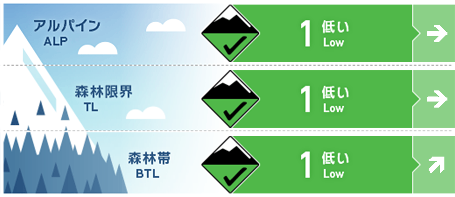
Alpine Good
Treeline Good
Below Treeline Good 日中の昇温と日射の影響に留意
信頼度:○ good □ Fair △ Low
Travel and Terrain Advice
Southerly winds have entered and a large temperature rise is forecast, so please pay attention to the changes in the snow cover surface layer during the day. Snowballs rolling on the snow surface are a telltale sign of a decrease in snow strength. Wet snow is so heavy that it is easy to scoop up your feet even if it is very small. When traversing steep slopes, etc., think about “terrain traps” below. Also, stay away from slopes with glide cracks, where there is a risk of all-layer avalanches. In the vicinity of the forest limit, there are places where the surface layer is partially monaka snow (the surface layer is hard, but it cracks when it slips, and the inside is soft). Please glide carefully while checking the situation. Have a nice day in spring
Avalanche Problem
全層雪崩 Glide slab


標高が低く、グライドクラックが既に入っている斜面。
点発生湿雪雪崩 Wet Loose snow


日中の昇温と日射で危険度は上昇。
ウインドスラブ Wind slab


概要
Avalanche
Yesterday (10th), many point-generated wet and snowfall avalanches of size 1 were observed on steep slopes that are strongly exposed to solar radiation in the below treeline.
Snowpack
On the southern slopes, where the elevation is lower than the forest limit, the snow cover enters a “spring cycle” in which snow in the surface layer melts and freezes repeatedly. Today's main concerns are the magnitude of the daytime temperature rise (forecast to rise 10 degrees Celsius from the previous day) and the effects of solar radiation. Currently, it is negative at the foot, but this is due to radiative cooling, and it is already around 0°C near the forest limit. In places with low elevations, regardless of direction, the strength of snow on the snow cover surface layer will decrease in the future, and wet point-generated avalanches will likely occur. In addition, glide cracks are also growing, and snow blocks rest in unstable conditions on the extreme terrain of the valley ridges. On the other hand, snow is still dry on the northern slopes, which are higher than the upper below treeline.
Weather
The Japan Meteorological Agency predicts southern winds, later, north winds, sunny, sometimes cloudy, and a high temperature of 17°C (elevation 418m) for the northern part of Nagano prefecture. At the foot of Mt. Hakuba (elevation 703m), the temperature is -5.4℃ (as of 5:00), and there is no new snowfall in the past 48 hours.
