
Avalanche Bulletin
更新日時: 2022/03/15 07:00
Niseko Yotei Yoichi Shiribeshi
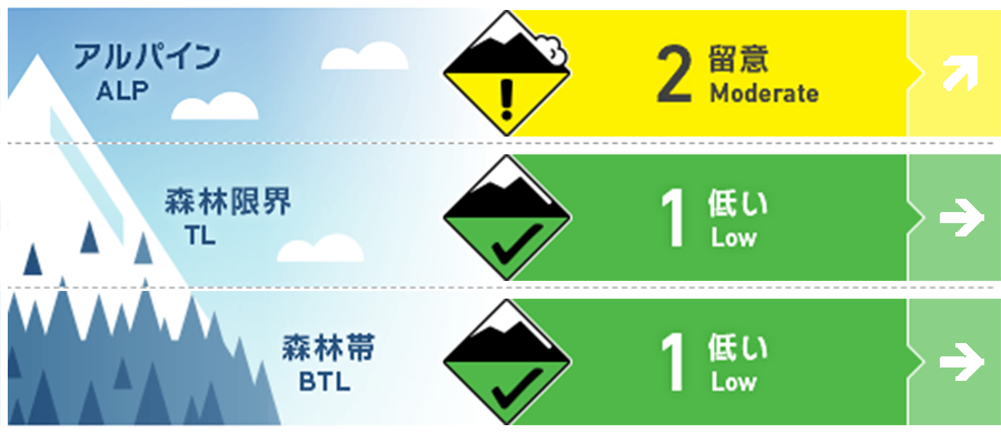
Alpine Fair もし、降雪の予報が発表された場合、アルパインでは局所のウインドスラブに注意を。If we received the forecasted new snow and string southerly wind speeds isolated pockets will build in the Alpine.
Treeline Fair 15 cm程度の降雪と風が強まらない限りにおいて、一般的に安全なコンディションです。Generally safe conditions unless we receive in excess of 15cm of new snow and increased wind speeds.
Below Treeline Good
信頼度:○ good □ Fair △ Low
Travel and Terrain Advice
The snow surface conditions in the backcountry are diverse, and the feeling of gliding is very different. Glide cracks are expanding, and snow bridges are likely to be weakening as well, so you should avoid them. We expect variable surface conditions in the backcountry at present where each ski or Snowboard turn may be drastically different. Glide cracks are wide open and should be avoided alongside the possibility of snow bridges of creeks and rivers now becoming weak.
Avalanche Problem
ウインドスラブ Wind slab


本日(火曜)は、強い南風を伴う降雪が予報されています。これにより、標高が高い場所では、風下側にウインドスラブの形成に注意する必要があります。危険の目安としては、15 cm程度の降雪と風の程度です。日中には風は収まる予報が出ていますが、この降雪によるスラブの形成具合がコンディション判断の材料になります。With new snowfall forecasted on Tuesday and strong southerly winds, wind slabs may form on lee slopes at higher elevations. We will need to receive in excess of 15cm of new snow to begin to see this hazard form and wind speeds are expected to lower during the day so the timing of when this snowfall will arrive will be determined if any slabs are created.
概要
Avalanche
No new avalanches have been observed and reported. No new activity has been reported.
Snowpack
At low altitudes, it is entering a cycle of thawing and freezing, and the temperature rises during the day, so the strength of the snow cover surface layer is decreasing. At high altitudes, crusts are formed due to the influence of southerly winds blowing and solar radiation. We have moved into a melt-freeze cycle at lower elevations with daily temperatures climbing above freezing resulting in the softening of the now surface. At higher elevations, southerly aspects have received solar input which will have created A crust on the surface.
Weather
Today (Tuesday), a low pressure will pass through the sky, so a strong southerly wind will blow in the morning, and it is forecast to subside during the day. It is said that the snowfall that starts during the day will continue until the middle of this week. The daytime freezing hardness is forecast to be around 400 m. A lower pressure system moves quickly across Japan on Tuesday bringing strong southerly Winds in the Morning which are expected to lower in speed during the day. We are forecast for snowfall throughout the day with snow showers continuing during the Mid part of the week. The freezing level will rise to 400m during the day.


