
Avalanche Bulletin
更新日時: 2022/03/21 06:00
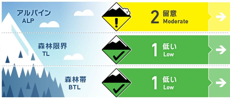
Myoko
Alpine Low
Treeline Fair
Below Treeline Good
信頼度:○ good □ Fair △ Low
Travel and Terrain Advice
In areas with heavy snowfall, pay attention to time-lapsed wind slabs at high elevations. This slab has a sluggish response to human stimuli, so it will not move without a large stimulus, but there is a possibility of inducing in topographic areas where snow cover is prone to instability, such as very steep, convex or unsupported shapes It is necessary to think and act. Also, at low altitudes, watch out for glide cracks and falling remaining snow blocks. Have a safe day
Avalanche Problem
ストームスラブ Storm slab


積雪が不安定化しやすい地形局所にて
ウインドスラブ Wind slab


積雪が不安定化しやすい地形局所にて
概要
Avalanche
No new avalanches were observed and reported yesterday (20th).
Snowpack
Conditions at the interface between fresh and old snow, which showed instability immediately after snowfall, are improving quickly, and multiple observations made yesterday have not reported significant vulnerabilities. The amount of snowfall until yesterday was about 5 to 30 cm, and there was considerable variation in the mountain area, and it seems that there were a lot of them from the west to the north.
Weather
The Japan Meteorological Agency predicts southern wind, daytime, north wind, rain or snow, cloudy, and a high temperature of 8℃ (elevation 13 m) from the morning for the Joetsu region of Niigata prefecture. At Myoko Sasagamine (elevation 1,310m), the temperature is -6℃ (as of 5:00), and there is no new snowfall in the past 12 hours.