
雪崩情報
更新日時: 2022/03/22 07:00
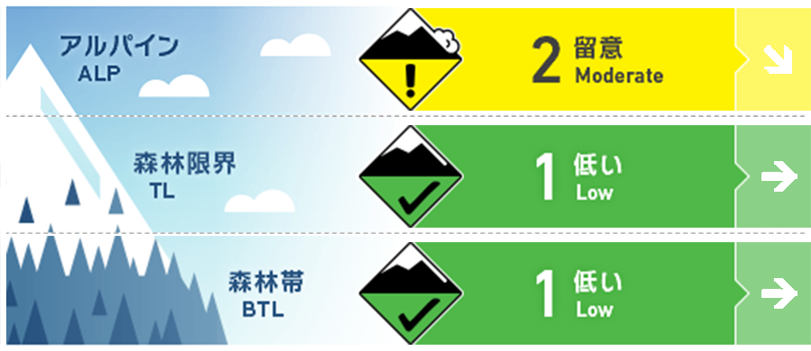
ニセコ・羊蹄・余市・尻別
アルパイン Good 稜線付近の局所にウインドスラブが形成しています。Isolated pockets of wind slab may have formed around ridgeline.
森林限界 Good
森林帯 Good
信頼度:○ good □ Fair △ Low
行動と地形の助言
直近の降雪は、旧雪の雪面状況を隠すので、標高によって多様な滑走感が楽しめるでしょう。凍結高度より低い標高では、昇温によって、新雪は重くなります。また、一般的な春の注意事項として、谷筋や川に架かるスノーブリッジに警戒してください。This latest new snowfall may mask the condition of the previous snow surface creating variable skiing and riding at different elevations. As freezing levels rise the lower elevations may become warm and heavy during the day. Regular spring travel precautions are required and be wary of snow bridges when crossing creeks and rivers.
留意すべき雪崩
点発生湿雪雪崩 Wet Loose snow


高い気温が続き、凍結高度は400 m以上まで上昇しますので、標高の低いところでは、濡れた雪による点発生雪崩の可能性が高まります。直近に降った雪も、この昇温のため、すぐに結合力を失うでしょう。とても急な斜面では点発生雪崩が観察できるかもしれません。Continued warm temperatures and a freezing level rising to above 400 meters will promote wet loose activity during the day at lower elevations. The latest new snow is likely to heat quickly and lose cohesion. We may see point release activity on steep terrain.
ウインドスラブ Wind slab


移動可能な新雪があり、強い西寄りの風が吹いていますので、標高の高いところでは小さいながらもウインドスラブが形成しています。このスラブは昇温などの影響を受けて硬く凍結した斜面に形成している可能性があります。東に面した斜面では、風で移動し、新しく形成したスラブを探してください。With new snow available to transport and strong winds from the west, we expect low volume slabs can be found at higher elevations. These slabs may have formed on a firm temperature affected previous snow surface. Look for any signs of fresh wind deposited snow across easterly aspects.
概要
雪崩
新しい雪崩の観察報告は入っていません。No new activity has been reported across the region.
積雪
一時的に冬の天気となり、昇温と日射の影響を受けた雪面に、荒天の雪が載っています。雪の量が多かった場所では、新雪と旧雪の境界面の結合状態が良くなっているか、確認する必要があります。旧雪内には不安定な要素はありません。A brief return to winter has seen the region receive a top-up on new snow that has fallen on a temperature and sun-affected previous sow surface. In areas of higher volume of accumulation, the bond between these layers may be overcome and will need to be tested. The lower pack remains in a stable condition
天候
週の始めに、標高の高いところで多少の降雪と強い風がありましたが、その後、高気圧に覆われ、凍結高度は上昇し、風も弱まる予報が出ています。今後、まとまった新雪は期待できない感じです。The early part of the week has seen snow showers and strong winds at higher elevations, a high-pressure system will begin to come into effect with freezing levels again rising and wind speeds decreasing. We are not expecting much in the way of new snow accumulation over the coming days


